
Pricing Change
New pricing for orders of material from this site will come into place shortly. Charges for supply of digital images, digitisation on demand, prints and licensing will be altered.
Keoldale


Farmstead (Period Unassigned)
Site Name Keoldale
Classification Farmstead (Period Unassigned)
Canmore ID 272914
Site Number NC36NE 94
NGR NC 3775 6657
Datum OSGB36 - NGR
Permalink http://canmore.org.uk/site/272914


- Council Highland
- Parish Durness
- Former Region Highland
- Former District Sutherland
- Former County Sutherland
NC36NE 94 3775 6657
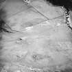
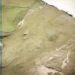
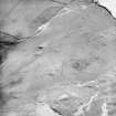
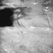
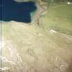
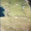
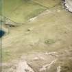
The footings of this farmstead, comprising an L-shaped building lying partly within a rectilinear enclosure, have been recorded on oblique aerial photography (RCAHMSAP 2004) lying to the SW of Loch Borralie.
Information from RCAHMS (KMM) 21 April 2005

