
Balnabroich


Farmstead (Post Medieval), Lime Kiln (18th Century) - (19th Century)
Site Name Balnabroich
Classification Farmstead (Post Medieval), Lime Kiln (18th Century) - (19th Century)
Alternative Name(s) Stylemouth
Canmore ID 27289
Site Number NO05NE 39
NGR NO 0997 5720
Datum OSGB36 - NGR
Permalink http://canmore.org.uk/site/27289


- Council Perth And Kinross
- Parish Kirkmichael (Perth And Kinross)
- Former Region Tayside
- Former District Perth And Kinross
- Former County Perthshire
Field Visit (5 May 1987)
NO05NE 39 0997 5720
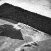
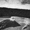
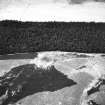
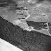
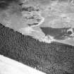
This farmstead, which was abandoned by 1863 (OS 1st edition, sheet 41), is situated 750m E of Croft na Coille on the W side of the head-dyke that separates the moorland to the E from the slightly better quality ground to the W. The farmstead comprises several rectangular buildings set around a yard, a kiln and a probable potato-store. The farmstead is fronted on the SE and SW by at least three small enclosures, but to varying degrees, all have been destroyed by a conifer plantation.
1. NO 0997 5721 This rectangular building lies on the ENE side of the yard and measures 9.3m NNW-SSE by 3.9m within walls up to 1m in thickness and 1.6m in height; in the SE corner there is a chimney-like recess and there is a blocked doorway central to the W side. Attached to the S end there is an outshot (6.5m WSW-ENE by 3.5m within walls 0.8m thick and 1m high) with an entrance central to the W side, while a further two compartments have been added to the N end. Overall these measure 9.1m NNW-SSE by 3.3m within walls up to 0.9m in thickness and 1.3m in height. A second building (NO 0997 5720) forms the S end of the yard and measures 6.5m WSW-ENE by 3.3m within walls up to 0.8m in thickness and 1m in height; there is an entrance midway along the N side. On the W side of the yard there is a building measuring 9.2m NNW-SSE by 3.1m over walls up to 0.6m in thickness and 1m in height; it has three compartments, each with an entrance on the ENE.
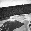
2. This probable potato-store is sunk into the slope on the SE side of the farmstead and measures 4.3m WSW-ENE by 1.4m and 0.7m in depth internally; the structure is open-ended to the WSW; it has a stone inner face and is also embanked with overall dimensions of 5.3m by 5.4m.
3. To the N, abutting the W side of the head-dyke, there is a kiln measuring 4.4m in external diameter and 1.5m in height; internally the bowl is 2.2m in diameter and 1m in depth with a flue on the SW. It is marked as a lime kiln on the 1st edition map.
Visited by RCAHMS (JRS) 5 May 1987
RCAHMS 1990
Measured Survey (1987)
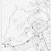
RCAHMS surveyed the hut circles, field system and Pitcarmick-type buildings at Balnabroich in 1987 at a scale of 1:2500. The resultant plan was redrawn in ink and published at a scale of 1:5000 (RCAHMS 1990, Fig. 108A).
Note (5 December 1997)
Five unroofed buildings, three enclosures and a lime kiln are depicted on the 1st edition of the OS 6-inch map (Perthshire 1867, sheet xli). Four unroofed buildings, one of which is in the same location as the lime kiln, and two enclosures are shown on the current edition of the OS 1:10000 map (1977).
Information from RCAHMS (SAH) 5 December 1997.

