
Pricing Change
New pricing for orders of material from this site will come into place shortly. Charges for supply of digital images, digitisation on demand, prints and licensing will be altered.
Keith Cemetery


Cemetery (Post Medieval)
Site Name Keith Cemetery
Classification Cemetery (Post Medieval)
Canmore ID 272784
Site Number NJ45SW 148
NGR NJ 42735 50748
Datum OSGB36 - NGR
Permalink http://canmore.org.uk/site/272784


- Council Moray
- Parish Keith
- Former Region Grampian
- Former District Moray
- Former County Banffshire
NJ45SW 148 42735 50748
For adjacent Old Burial Ground, see NJ45SW 5
INVENTORY OF GRAVEYARD AND CEMETERY SITES IN SCOTLAND REFERENCE:
N.B. This reference applies to NJ45SW 5 and NJ45SW 148 collectively
Address: Old Keith Burial Ground and Cemetery, Keith, Moray
Postcode: AB55 5DU
Status: In current use for burials
Size: Old Burial Ground: 0.28 hectares, 0.69 acres
Size: Cemetery: 0.60 hectares, 1.47 acres
Polygon: Yes
TOIDs: Old Burial Ground: 1000000173211533, 1000000173211539, 1000000173211732
TOIDs: Cemetery: 1000000173211526, 1000000173211527, 1000000173211528, 1000000173211529, 1000000173211530, 1000000173211531, 1000000173211532, 1000000173211534, 1000000173211535, 1000000173211537, 1000000173211540
Number of gravestones: c1000
Earliest gravestone: 1689
Most recent gravestone: 2003
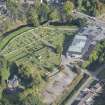
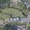
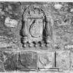
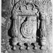
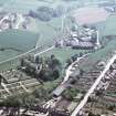
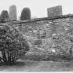
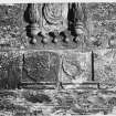
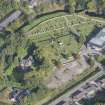
Description: Graveyard associated with a church (relocated 1816 to St Rufus) with later public cemetery adjoining. Unusual topography - on three distinct levels. Entry on the SE side of the site via the main double date, up the right-hand side of the supermarket (10 metres distant), leads straight to foot of a broad stone stairway. At the top of the stair is the highest, and original level of the graveyard. It contains approximately 25% of the stones which are predominantly 18th and 19th century. There is a considerable drop from the top to the two lower levels, which are Victorian and later extensions. Along the N edge of the top level there is a vertical drop of more than 7 metres to the level below, supported by a heavily buttressed retaining wall. There are two sets of imposing stairways connected the top level with the lower ones. The one referred to previously bears the date 1870. The height difference between the bottom two levels is relatively insignificant and they are connected by a gently sloping path. The original Kirktown of Keith, or Old Town, was located immediately S of the graveyard. In 1750 is was subjected by the 5th Earl of Findlater to one of the first planned town expansions, called New Keith, on the S. Shortly after, this was followed by Fife-Keith on the N, by the Earl of Fife. So the town thrived during this period, and on through the 19th and early 20th centuries with agricultural improvements, arrival of railway, whisky and textile industries. The varierty of stones reflects this background of development and variety of social standing and occupation. There is considerable variety of type of memorial and level of ornamentation. There are several enclosures, some impressive wall monuments, recumbent stones, table stones, pillars, obelisks, sculptures etc. Allt he pre-19th Century stones are on the top level, where the ground is uneven and numerous upright headstones tilt or have collapsed. Most are orientated E-W on the top level, but several enclosures and wall monuments are orientated N-S. On the lower levels roughly 20% of the stones are aligned N-S.
Data Sources: Graveyard Recording Form 9 March 2003; OS MasterMap checked 14 June 2005

