
Lewis, Uamh'a Ghobha


Building (Post Medieval)
Site Name Lewis, Uamh'a Ghobha
Classification Building (Post Medieval)
Canmore ID 272575
Site Number NB55NE 15
NGR NB 56012 57555
Datum OSGB36 - NGR
Permalink http://canmore.org.uk/site/272575


- Council Western Isles
- Parish Barvas
- Former Region Western Isles Islands Area
- Former District Western Isles
- Former County Ross And Cromarty
NB55NE 15 56012 57555
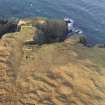
The footings of this rectangular building have been recorded on oblique aerial photography (RCAHMSAP 2004) lying on the headland above Uamh'a Ghobha. It is depicted on the current edition of the OS 1:10000 map (1973), but is not shown on the 1st edition of the OS 6-inch map (Island of Lewis Ross-shire 1853, sheet 6).
Information from RCAHMS (KMM) 23 May 2005

