Pricing Change
New pricing for orders of material from this site will come into place shortly. Charges for supply of digital images, digitisation on demand, prints and licensing will be altered.
Upcoming Maintenance
Please be advised that this website will undergo scheduled maintenance on the following dates:
Thursday, 9 January: 11:00 AM - 3:00 PM
Thursday, 23 January: 11:00 AM - 3:00 PM
Thursday, 30 January: 11:00 AM - 3:00 PM
During these times, some functionality such as image purchasing may be temporarily unavailable. We apologise for any inconvenience this may cause.
Pitcarmick
Pitcarmick Building (Early Medieval)
Site Name Pitcarmick
Classification Pitcarmick Building (Early Medieval)
Alternative Name(s) Cultalonie
Canmore ID 27250
Site Number NO05NE 136
NGR NO 05985 58126
Datum OSGB36 - NGR
Permalink http://canmore.org.uk/site/27250
- Council Perth And Kinross
- Parish Kirkmichael (Perth And Kinross)
- Former Region Tayside
- Former District Perth And Kinross
- Former County Perthshire
Field Visit (9 June 1988)
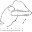
The remains of this Pitcarmick-type building are situated on a gentle NE-facing slope on the N side of the Allt Cul na Coille. It was obscured by deep heather on the date of visit but measures 28.5m in length and varies from 6.5m in width at the ENE end to 9m midway along its length at the WSW and over walls up to 2m in thickness and 0.2m in height. Occasional inner and outer facing-stones are visible but no entrance. The eastern two-thirds of the interior is sunken and the building is widest at the W end of the hollow. Attached to the NW corner of the building there is a small annexe or enclosure measuring 8.3m ENE-WSW by c.5m internally. A larger enclosure (22m E-W by 11m internally) is attached to the NNW side of the building and another (c.20m N-S by 18.5m internally) is situated on the SW.
A subrectangular building, measuring 10m ENE-WSW by 7.3m over low wall-footings, lies 7m from the ENE end of the Pitcarmick-type building. A small outshot is situated at its ENE end and there is no evidence of an entrance.
Visited by RCAHMS (JRS) 9 June 1988.
RCAHMS 1990
Measured Survey (19 May 1988)
RCAHMS surveyed the hut circles, field system and buildings at Pitcarmick (North) by self-reducing alidade and plane-table on 19 May 1988 at a scale of 1:1250. The resultant plan was redrawn in ink and published at a scale of 1:2500 (RCAHMS 1990, Fig. 154.4B).
Measured Survey (1988)
RCAHMS surveyed the Pitcarmick-type building at Pitcarmick (North) (NO 0598 5812) in 1988 with self-reducing alidade and plane-table at a scale of 1:250. The plan was redrawn in ink and published at a scale of 1:500 (RCAHMS 1990, Fig. 303.2).


