Accessibility

Font Size

100% 150% 200%

Background Colour

Default Contrast
Close Reset

Edrom

Enclosure(S) (Period Unassigned)(Possible), Linear Feature(S) (Period Unassigned)

Site Name Edrom

Classification Enclosure(S) (Period Unassigned)(Possible), Linear Feature(S) (Period Unassigned)

Canmore ID 271883

Site Number NT85NW 77

NGR NT 82760 55720

Datum OSGB36 - NGR

Permalink http://canmore.org.uk/site/271883

Ordnance Survey licence number AC0000807262. All rights reserved.
Canmore Disclaimer. © Bluesky International Limited 2025. Public Sector Viewing Terms

Toggle Aerial | View on large map

Digital Images

Oblique aerial view centred on the possible enclosures and linear cropmarks with the church, burial ground, lodge, school, farmhouses, farmsteadings and cottages adjacent, taken from the ENE.
Oblique aerial view centred on the possible enclosures and linear cropmarks with the church, burial ground, lodge, school, farmhouses, farmsteadings and cottages adjacent, taken from the ENE.Oblique aerial view centred on the cropmarks of the possible enclosures with the church, burial-ground, manse and cropmarks of the pit-alignments adjacent, taken from the SSE.Oblique aerial view centred on the possible enclosures and linear cropmarks with the church, burial ground, lodge, school, farmhouses, farmsteadings and cottages adjacent, taken from the ENE.Oblique aerial view centred on the cropmarks of the possible enclosures with the church, burial-ground, manse and cropmarks of the pit-alignments adjacent, taken from the NW.Oblique aerial view centred on the cropmarks of the possible enclosures and linear cropmarks with the church, burial ground, manse, country house, lodge, school, farmhouses, farmsteadings and cottages adjacent, taken from the NNE.Oblique aerial view centred on the possible enclosures and linear cropmarks with the church, burial ground, manse, lodge, school, farmhouses, farmsteadings and cottages adjacent, taken from the NNE.Oblique aerial view centred on the cropmarks of the pit-alignments with the church, burial-ground, manse and cropmarks of the possible enclosure adjacent, taken from the S.Oblique aerial view centred on the cropmarks of the possible enclosures with the church, burial-ground, manse and cropmarks of the pit-alignments adjacent, taken from the NW.Oblique aerial view centred on the cropmarks of the pit-alignments with the church, burial-ground, manse and cropmarks of the possible enclosure adjacent, taken from the SE.General oblique aerial view centred on the cropmarks of the pit-alignments and possible enclosure and the church, burial-ground and manse, taken from the NE.Oblique aerial view centred on the cropmarks of the possible enclosures and linear cropmarks with the church, burial ground, manse, country house, lodge, school, farmhouses, farmsteadings and cottages adjacent, taken from the NE.Oblique aerial view centred on the possible enclosures and linear cropmarks with the church, burial ground, manse, lodge, school, farmhouses, farmsteadings and cottages adjacent, taken from the NE.Oblique aerial view centred on the cropmarks of the pit-alignments with the church, burial-ground, manse and cropmarks of the possible enclosure adjacent, taken from the NE.

Administrative Areas

  • Council Scottish Borders, The
  • Parish Edrom
  • Former Region Borders
  • Former District Berwickshire
  • Former County Berwickshire

Archaeology Notes

NT85NW 77 NT 82760 55720

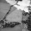
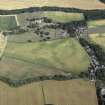
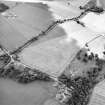
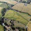
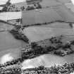
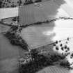
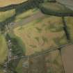
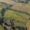
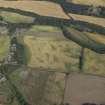
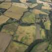
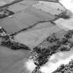
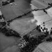
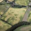
At least three possible rectilinear ditched enclosures have been recorded on oblique aerial photographs (RCAHMSAP 2003), lying on level ground to the S of Edrom Parish Church (NT85NW 11.01). The cropmarks are faint and indefinite, but the enclosures may be related to the policies of Edrom House (NT85NW 50). What may be a circular feature is visible within the northernmost of the enclosures. What are probably field drains are visible running NW and SE across the field.

Information from RCAHMS (MMB) 15 February 2005

References

MyCanmore Image Contributions


Contribute an Image

MyCanmore Text Contributions