
Rohallion Castle


Tower House (Medieval)
Site Name Rohallion Castle
Classification Tower House (Medieval)
Alternative Name(s) Craig Ruenshin
Canmore ID 27176
Site Number NO04SW 22
NGR NO 0387 4008
Datum OSGB36 - NGR
Permalink http://canmore.org.uk/site/27176


- Council Perth And Kinross
- Parish Little Dunkeld
- Former Region Tayside
- Former District Perth And Kinross
- Former County Perthshire
NO04SW 22 0387 4008.
(NO 0387 4008) Rohallion Castle (NR)
OS 6" map, Perthshire, 2nd ed. (1901)
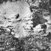
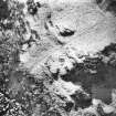
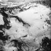
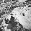
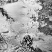
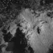
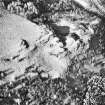
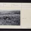
The ruins of Rohallion Castle, an old fortalice, consist of a central block, oblong on plan with round towers at two diagonally opposite corners and a series of outer defences. There are shot-holes in the towers.
The last time the castle was occupied (W Marshall 1881) was during the period following the Reformation in Scotland; it was also a hiding-place of William, 4th Lord Ruthven, after the Raid of Ruthven in 1582. The building is almost certainly 16th century work.
T M'Laren 1920
The remains of Rohallion Castle, of Z-plan, with walls standing c. 1.0m high, are generally as described and planned. Name confirmed.
Surveyed at 1:10,000.
Visited by OS (RD) 22 February 1971.

