
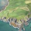
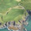
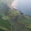
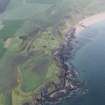
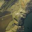
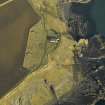
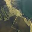
Kincraig Battery


Military Camp (20th Century)
Site Name Kincraig Battery
Classification Military Camp (20th Century)
Alternative Name(s) Forth Defences
Canmore ID 271443
Site Number NT49NE 44.05
NGR NT 4672 9999
NGR Description Centred NT 4672 9999
Datum OSGB36 - NGR
Permalink http://canmore.org.uk/site/271443


- Council Fife
- Parish Elie
- Former Region Fife
- Former District North East Fife
- Former County Fife
NT49NE 44.05 centred 4672 9999
Falls mainly on map sheet NO49SE
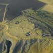
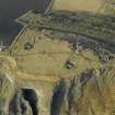
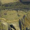
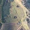
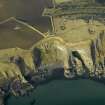
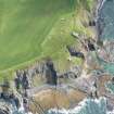
The accommodation camp for crew and support staff is visible on vertical air photographs (106G/Scot/UK 4, Part II, 6165-7, flown 14 April 1946), immediately to the N of the gun-emplacements. Many hut bases and other evidence for the camp can be seen on the reverse slope.
Information from RCAHMS (DE), March 2005
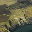
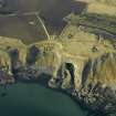
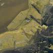
Little remains of a large accommodation camp which was situated on the N-facing slope og Kincraig Hill about 110m N of the gun-emplacements. A few concrete hut bases survive in amongst gorse bushes an the reverse slope of the hill.
Field Visit (8 November 2023)
None of the buildings in the camp that serviced the Kincraig Battery survive, although visible fragmentary remains survive of the E Guardhouse (NT49NE 44.23) on the upper terrace, the military road (NO40SE 1231) and the NAAFI (NT49NE 44.33) on the central terrace, and an ablutions block (NO40SE 1232), a latrine (NO40SE 1233) and two septic tanks (NO40SE 1234; NO40SE 1235) on the lower terrace. In addition, a series of culverts (NO40SE 1227) are situated on the upper terrace, with drains (NO40SE 1222; NO40SE 1234) on the central and lower terraces. In addition, flights of steps (NO40SE 1223; NO40SE 1224) occur at intervals along the scarps between the terraces.
The camp was constructed alongside the battery from 1939 (Barclay and Morris 2019, 215) and an aerial photograph taken on 1 August 1940 (Barclay and Morris 2019, 217 Fig. 12.2) shows various buildings disposed across the three terraces - most of which can be identified from plans preserved in the Fort Record Book held by the National Archives at Kew. On the upper terrace above the road, the structures running from ENE to WSW, comprise a small building of unknown purpose, the sergeants’ quarters, four accommodation huts, a battery office, and the NAAFI office. On the central terrace below the road, there are the officers’ mess, the sergeants’ mess, an accommodation hut, a cookhouse-cum-dining room, two further accommodation huts, and the western guardroom. Finally, on the lower terrace there are three accommodation huts, an ablutions block, a latrine, a coal store and a second septic tank. A plan in the Fort Record Book dated ‘Dec 1941’ shows some additional structures, including the easterly guardhouse on the upper terrace, the NAAFI (named ‘Institute’) and a coal yard on the central terrace; together with another ablutions block (attached to the coal store) and a second septic tank close to the camp’s NW corner. Another plan in the Fort Record Book entitled ‘Secret Copy Drg No East/FSS/51’, dated ‘22.7.42’ shows that a ‘miniature range’ had been added to the upper terrace between the battery plotting room and the sergeants’ quarters; that a small store and a meat store had been inserted into the central terrace, while a library had been constructed on the lower terrace to the E of the three accommodation huts. A later aerial photograph (106G/Scot/UK/0004 6164) taken on 14 April 1946 shows that a walled compound had also been introduced immediately W of the western guardhouse.
The camp was decommissioned in October 1956 (Barclay and Morris 2019, 222) and those buildings that were not built of reinforced cast concrete were sold and removed soon afterwards. Another aerial photograph (FDL/7343/13 0783) taken on 13 October 1973 shows that only the E guardhouse, the NAAFI and a latrine still remained standing
Visited by HES Archaeological Survey (A. K. Kilpatrick, P. M. Bethune), 8 November 2023

