
Kincraig Battery, Battery Observation Post


Observation Post (20th Century)
Site Name Kincraig Battery, Battery Observation Post
Classification Observation Post (20th Century)
Alternative Name(s) Forth Defences
Canmore ID 271441
Site Number NT49NE 44.03
NGR NT 46790 99958
Datum OSGB36 - NGR
Permalink http://canmore.org.uk/site/271441


- Council Fife
- Parish Elie
- Former Region Fife
- Former District North East Fife
- Former County Fife
NT49NE 44.03 46790 99958
The battery observation post (BoP) is extant and is visible on vertical air photographs (106G/Scot/UK 4, Part II, 6165-7, flown 14 April 1946).
Information from RCAHMS (DE), March 2005 and J Guy 1993
The Battery Obsevration Post (BoP) has been reduced to a pile of rubble.
Visited by RCAHMS (DE), 16 May 2007
Field Visit (7 November 2023)
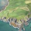
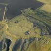
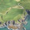
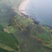
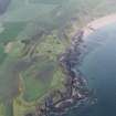
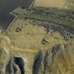
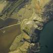
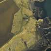
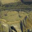
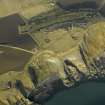
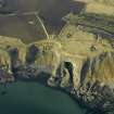
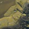
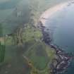
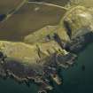
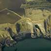
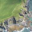
What remains of this battery observation post is situated within the remnants of a bund on the summit of Kincraig Hill about 30m NNW of the central gun emplacement of the battery (NT49NE 44.02). It has been demolished, the debris extending roughly 15m from N to S by 10m transversely and piled up to 1.7m in height. There is only one fragmentary length of what may be a standing brick wall, but apart from such brickwork the debris also comprises many fragmentary cast concrete slabs. Some of these retain hooks for the attachment of camouflage netting. Amongst the rubble is a prone concrete pillar with chamfered edges and a narrow channel leading to an inset for a junction box in its present upper surface. This may have supported a depression range finder.
The observation post is described in the Fort Record Book (WO192/255) held by the National Archives at Kew as having been a two-storey structure designed to appear as an abandoned domestic building (Barclay and Morris 2019, 215-6). The upper storey contained the observation platform with a pedestal for a depression range finder, while the telephone exchange was on the ground floor. This building is shown on an aerial photograph flown on 1 August 1940 (Barclay and Morris 2019, 217, fig 12.2) and is shown under camouflage on another aerial photograph (M/081/E309 02242) flown on 6 April 1941. However, the co-ordinates in the Fort Record Book indicate that the pedestal was moved, and this seems to confirm that the observation post was subsequently rebuilt a few metres W of the original position by June 1942. The later plan of the battery’s layout entitled ‘Secret Copy No.7’, dated ‘22.7.42’, which is also included in the Fort Record Book, shows this new building and identifies it as the ‘B.O.P.’ There is also an entry describing its equipment. A store was situated immediately to its S. A third aerial photograph (M/042/NLA/067 0016) flown on 14 August 1943 shows it under camouflage, while another (106G/Scot/UK/0004 6163) flown on 14 April 1946 shows this had been removed and that the building was surrounded by a bund.
Visited by HES Archaeological Survey (A. T. Welfare, J. M. Hepher), 7 November 2023

