
Forth Defences, Outer, Inchkeith, Fire Command Post And Port War Signal Station


Naval Signal Station (First World War), Naval Signal Station (Second World War), Observation Post (First World War), Observation Post (Second World War)
Site Name Forth Defences, Outer, Inchkeith, Fire Command Post And Port War Signal Station
Classification Naval Signal Station (First World War), Naval Signal Station (Second World War), Observation Post (First World War), Observation Post (Second World War)
Alternative Name(s) Forth Defences
Canmore ID 271439
Site Number NT28SE 5.12
NGR NT 29332 82802
Datum OSGB36 - NGR
Permalink http://canmore.org.uk/site/271439


- Council Fife
- Parish Kinghorn
- Former Region Fife
- Former District Kirkcaldy
- Former County Fife
The Port War Signal Station lay on Inchkeith in both First and Second World Wars. The PWSS was responsible for control of access to the estuary and would have warned the gun batteries upriver of what ships were approaching.
Information from HS/RCAHMS World War One Audit Project (GJB) 4 November 2013.
NT28SE 5.12 29332 82802
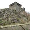
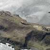
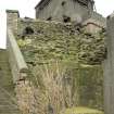
A brick and concrete building in several parts is situated on a rock outcrop immediately S of the lighthouse.
The structure consists of several buildings in one group, all with viewing paltofrms. External steel ladders survive on the S elevation with many of the steel framed windows still in situ.
J Guy 1993,; NMRS MS 810/3, 42
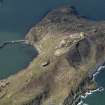
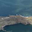
The Port War Station is situated on or near the highest pont of the Island (c.50m OD) about 79m SSE of the Lighthouse (NT28SE 6.00). The station is a three storey tower of brick (ground floor) and concrete with viewing platforms. accessed by external metal stairs. The building has been built within the boundary of the 16th century fortification (NT28SE 1.00), the walls of which survive on the S and E lower slopes.
The mainly brick ground floor building measures 16m by 5.8m overall with upper storeys wider. The ground floor building where the remnants of wooden lining and floor with a fireplace were noted in one room along with what may have been a wooden telephone box. Further rooms were seen to the SE. Entrance to the ground floor was from the courtyard to the W.
The upper storeys were not entered as the stairs were in a dangerous condition.
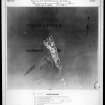
The building is annotated as 'Signal Station on both the Ordnance Survey pre First World War plan and the WO plan (RCAHMS MS 879/83). The plans depict the signal station as an area very similar to that of the ground floor brick building, but without the upper storeys, suggesting that this is an earlier structure.
Visited by RCAHMS (DE, AL), 25 February, 4th and 5th March 2009
Project (March 2013 - September 2013)
A project to characterise the quantity and quality of the Scottish resource of known surviving remains of the First World War. Carried out in partnership between Historic Scotland and RCAHMS.

