
Forth Defences, Inchkeith, Radar Unit And Fire Control Position, Pf Cell Nos 1-4


Observation Post (Second World War)(Possible), Observation Post(S) (First World War), Officers Quarters (Second World War), Radar Site (20th Century), Telephone Exchange (Second World War)
Site Name Forth Defences, Inchkeith, Radar Unit And Fire Control Position, Pf Cell Nos 1-4
Classification Observation Post (Second World War)(Possible), Observation Post(S) (First World War), Officers Quarters (Second World War), Radar Site (20th Century), Telephone Exchange (Second World War)
Alternative Name(s) Forth Aa Defences
Canmore ID 271436
Site Number NT28SE 5.09
NGR NT 2942 8262
NGR Description Centred NT 2942 8262
Datum OSGB36 - NGR
Permalink http://canmore.org.uk/site/271436


- Council Fife
- Parish Kinghorn
- Former Region Fife
- Former District Kirkcaldy
- Former County Fife
NT28SE 5.09 c.2942 8262
NT 294 826. Radar site, a low power surface watching set, which was used to provide a general radar picture for coast artillery Area Commanders. It operated either in a wooden cabin or was installed in a fire command post.
Information via e-mail from Mr I Brown, November 1998
NT28SE 5.09 centred 2942 8262
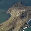
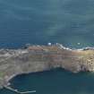
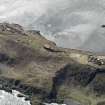
A group of six buildings, five of which are concrete Fire Control points and one a brick and concrete telephone exchange are situated on the ridge between B Group (NT28SE 5.06) and F Group (NT28SE 5.01) gun emplacements.
The fire control positions have low sloping roofs supported by steel beams, most now have grass growing on them. Internally, PF No.4 Cell is wooden lined and a painted wall sign 'No.4 Cell' identifies this particular position. There are three other PF Cells numbered 1 to 3.
The main 9.2-inch gun emplacement Battery Observation Post has several underground chambers with three viewing platforms facing S, E and W. This post has an entrance from the N via a sunken concrete linedpathway and a second entrance from the W via a sunken pathway and concrete stairs immediately S of the Officers' Quarters..
No evidence could be found for the radar site noted by Mr I Brown, but the fixture for the aerial may be buried under more recent vegetation and grass.
The telephone exchange building was not entered on the dates of visit.
Visited by RCAHMS (DE, AL), 25 February, 4th and 5th March 2009
Project (March 2013 - September 2013)
A project to characterise the quantity and quality of the Scottish resource of known surviving remains of the First World War. Carried out in partnership between Historic Scotland and RCAHMS.
Note (6 November 2013)
A Fire Command Post [F.C. Post (South)] is shown on a map of the island (The National Archives WO 78/5161) connected by underground passageways to four position finding cells (P.F.cell) number nos.1-4. The Fire Command post would have been for the 9.2-inch gun to the south (NT28SE 5.06).
In the Second World War a telephone exchange building and to the south of it a building annotated 'Off's Qtrs (officer's quarters) and No.4 P.F. cell is annotated 'Shelter' (The National Archives WO 192/251).
Information from RCAHMS (AKK) 6 November 2013

