Groat's Loch
Building (Period Unassigned)
Site Name Groat's Loch
Classification Building (Period Unassigned)
Canmore ID 271080
Site Number ND34SW 387
NGR ND 31197 40735
Datum OSGB36 - NGR
Permalink http://canmore.org.uk/site/271080
- Council Highland
- Parish Wick
- Former Region Highland
- Former District Caithness
- Former County Caithness
ND34SW 387 ND 31197 40735
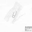
This building is situated on a narrow, SE-facing terrace in heather moorland about 180m W of the S end of Groat's Loch. Round-ended on plan, it measures 23.5m from NNE to SSW by up to 9.6m transversely over a wall about 1.7m in thickness and 0.8m in internal height. Both the inner and outer faces can be seen at the SSW end of the ESE side, and several inner facing-stones are visible elsewhere, comprising edge-set slabs up to 1.25m in length and 0.5m in height. There is an entrance gap, some 1.5m in width, at the centre of the SSW end, and there is a partition wall about 6m from the gap.
(YARROWS04 018)
Visited by RCAHMS (JRS) 24 May 2004.
Measured Survey (12 August 2004)
RCAHMS surveyed the building at Groat’s Loch on 12 August 2004 with plane table and self-reducing alidade at a scale of 1:250. The plan was later redrawn in ink and used as the basis of an illustration produced at a scale of 1:500.


