
Pricing Change
New pricing for orders of material from this site will come into place shortly. Charges for supply of digital images, digitisation on demand, prints and licensing will be altered.
Upcoming Maintenance
Please be advised that this website will undergo scheduled maintenance on the following dates:
Thursday, 9 January: 11:00 AM - 3:00 PM
Thursday, 23 January: 11:00 AM - 3:00 PM
Thursday, 30 January: 11:00 AM - 3:00 PM
During these times, some functionality such as image purchasing may be temporarily unavailable. We apologise for any inconvenience this may cause.
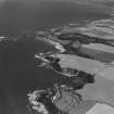
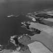
Seacliff


Ditch (Period Unassigned)
Site Name Seacliff
Classification Ditch (Period Unassigned)
Canmore ID 270795
Site Number NT68SW 65
NGR NT 6015 8478
Datum OSGB36 - NGR
Permalink http://canmore.org.uk/site/270795


- Council East Lothian
- Parish Whitekirk And Tyninghame
- Former Region Lothian
- Former District East Lothian
- Former County East Lothian
Field Visit (1996)
Viewed from the bottom of the cliff a U-shaped ditch was seen cut into the soil and rock and now grass covered. The ditch appeared to be 2m in depth and 2m wide at the top narrowing to 1m at the bottom. This may be associated with the fort NT 68 SW 30.
Site recorded by GUARD during the Coastal Assessment Survey for Historic Scotland, 'The Firth of Forth from Dunbar to the Coast of Fife' 26th February 1996.
Note (17 March 2015)
The ditch identified in 1996 is likely to be that relating to the chapel and burial ground described under NT68SW 17 and excavated in 2005 and 2008.
Information from RCAHMS (LMcC) 17th April 2015

