
South Ronaldsay, Herston Hill


Radar Site (20th Century)
Site Name South Ronaldsay, Herston Hill
Classification Radar Site (20th Century)
Alternative Name(s) R3; Midtown
Canmore ID 270448
Site Number ND49SW 28.01
NGR ND 41509 91469
Datum OSGB36 - NGR
Permalink http://canmore.org.uk/site/270448


- Council Orkney Islands
- Parish South Ronaldsay
- Former Region Orkney Islands Area
- Former District Orkney
- Former County Orkney
ND49SW 41509 91469
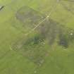
The concrete platform for the mobile radar unit is situated 12m SW of a fence line on the S side of the gun emplacements. The concrete or breeze block ramp to allow the unit to be placed on top of the platfrom has been removed, but some of the posts making up the Gl-mat are still in situ.
The battery was supplied with a Gl Mk II radar set. (PRO WO 166/7270).
Visited by RCAHMS (DE), August 1996

