
Pricing Change
New pricing for orders of material from this site will come into place shortly. Charges for supply of digital images, digitisation on demand, prints and licensing will be altered.
Upcoming Maintenance
Please be advised that this website will undergo scheduled maintenance on the following dates:
Thursday, 9 January: 11:00 AM - 3:00 PM
Thursday, 23 January: 11:00 AM - 3:00 PM
Thursday, 30 January: 11:00 AM - 3:00 PM
During these times, some functionality such as image purchasing may be temporarily unavailable. We apologise for any inconvenience this may cause.
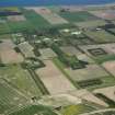
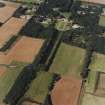
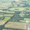
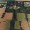
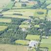
Gordonstoun House


Garden (Period Unassigned)
Site Name Gordonstoun House
Classification Garden (Period Unassigned)
Canmore ID 269769
Site Number NJ16NE 7.13
NGR NJ 1861 6860
Datum OSGB36 - NGR
Permalink http://canmore.org.uk/site/269769


- Council Moray
- Parish Drainie
- Former Region Grampian
- Former District Moray
- Former County Morayshire
NJ16NE 7.13 1861 6860
Cropmarks, possibly associated with the gardens of Gordonstoun house, have been recorded on oblique aerial photography (RCAHMSAP 2000) lying to the S of the present gardens.
Information from RCAHMS (KMM) 6 January 2005

