Accessibility

Font Size

100% 150% 200%

Background Colour

Default Contrast
Close Reset

Huntingtower

Drain(S) (Period Unassigned), Field Boundary(S) (Period Unassigned)

Site Name Huntingtower

Classification Drain(S) (Period Unassigned), Field Boundary(S) (Period Unassigned)

Alternative Name(s) Huntingtower 2

Canmore ID 26885

Site Number NO02SE 35
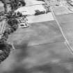
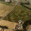
NGR NO 08254 24964

NGR Description NO 0755 2496 to NO 0874 2488

Datum OSGB36 - NGR

Permalink http://canmore.org.uk/site/26885

Ordnance Survey licence number AC0000807262. All rights reserved.
Canmore Disclaimer. © Bluesky International Limited 2025. Public Sector Viewing Terms

Toggle Aerial | View on large map

Digital Images

Huntingtower Linear Cropmarks trial excavation
Unidentified feature.
Huntingtower Linear Cropmarks trial excavation
Unidentified feature.Huntingtower Linear Cropmarks trial excavation
Unidentified linear feature.Huntingtower Linear Cropmarks trial excavation
Unidentified excavation photograph.Huntingtower Linear Cropmarks trial excavation
Unidentified linear feature.Huntingtower Linear Cropmarks trial excavation
Unidentified excavation photograph.Huntingtower Linear Cropmarks trial excavation
View of ditch running across different excavated sections.Huntingtower Linear Cropmarks trial excavation
Unidentified linear feature.Huntingtower Linear Cropmarks trial excavation
Unidentified excavation photographs.Oblique aerial view centred on the cropmarks of an enclosure, pit-circle, Roman Road, linear cropmarks, pits and pit-alignment with linear cropmarks adjacent, taken from the NNE.Oblique aerial view centred on the cropmarks of an enclosure, pit-circle, Roman Road, linear cropmarks, pits and pit-alignment with linear cropmarks adjacent, taken from the E.Oblique aerial view centred on the cropmarks of an enclosure, pit-circle, Roman Road, linear cropmarks, pits and pit-alignment with linear cropmarks and castle adjacent, taken from the E.RCAHMSAP 77 (c079 250)Oblique aerial view.Oblique aerial view.Oblique aerial view.Huntingtower Linear Cropmarks trial excavation
Unidentified excavation photographs.Huntingtower Linear Cropmarks trial excavation
Unidentified section.Huntingtower Linear Cropmarks trial excavation
Unidentified excavation photograph.Huntingtower Linear Cropmarks trial excavation
Excavated ditch section.Excavation photos G Barclay CEU 1977 (NB most negs not  printed)Excavation photos G Barclay CEU 1977 (NB most negs not  printed)Excavation photos G Barclay CEU 1977 (NB most negs not  printed)Excavation photos G Barclay CEU 1977 (NB most negs not  printed)Excavation photos G Barclay CEU 1977 (NB most negs not  printed)Huntingtower, NO02SE 35, Ordnance Survey index card, page number 6, RectoHuntingtower, NO02SE 35, Ordnance Survey index card, page number 40, RectoHuntingtower Linear Cropmarks trial excavation
Unidentified feature.Huntingtower Linear Cropmarks trial excavation
Unidentified excavation photograph.Huntingtower Linear Cropmarks trial excavation
Unidentified excavation photographs.Oblique aerial view
Oblique aerial view.Oblique aerial view.Oblique aerial view.Oblique aerial view.RCAHMSAP 82 (C079 250)Oblique aerial view.Oblique aerial view of linear cropmarks under excavation.Oblique aerial view of linear cropmarks under excavation.Huntingtower Linear Cropmarks trial excavation
Linear feature.Huntingtower Linear Cropmarks trial excavation
Linear feature in section.Huntingtower Linear Cropmarks trial excavation
Unidentified feature.Huntingtower Linear Cropmarks trial excavation
Section through linear feature.Huntingtower Linear Cropmarks trial excavation
Working shot early in excavation.Excavation photos G Barclay CEU 1977 (NB most negs not  printed)Excavation photos G Barclay CEU 1977 (NB most negs not  printed)Excavation photos G Barclay CEU 1977 (NB most negs not  printed)Excavation photos G Barclay CEU 1977 (NB most negs not  printed)Excavation photos G Barclay CEU 1977 (NB most negs not  printed)Hunting Tower Cursos-PerthOblique aerial view
Oblique aerial view
Oblique aerial viewHuntingtower, NO02SE 35, Ordnance Survey index card, page number 29, RectoHuntingtower, NO02SE 35, Ordnance Survey index card, page number 32, RectoHuntingtower, NO02SE 35, Ordnance Survey index card, page number 33, RectoHuntingtower, NO02SE 35, Ordnance Survey index card, page number 35, RectoHuntingtower Linear Cropmarks trial excavation
Excavation photograph.Huntingtower Linear Cropmarks trial excavation
Unidentified linear feature.Huntingtower Linear Cropmarks trial excavation
View of trench and ditches.Huntingtower Linear Cropmarks trial excavation
Excavated ditch.Huntingtower Linear Cropmarks trial excavation
Ditch edge.Oblique aerial photography, supposedly of Huntingtower linear cropmarks but unidentified.
Oblique aerial view centred on the cropmarks of an enclosure, pit-circle, Roman Road, linear cropmarks, pits and pit-alignment with linear cropmarks adjacent, taken from the N.Oblique aerial view.Oblique aerial view.RCAHMSAP 82 (c079 250)RCAHMSAP 82 (c079 250)Oblique aerial view.Oblique aerial view.Ground view of linear cropmarks.Huntingtower Linear Cropmarks trial excavation
Excavation photograph.Huntingtower Linear Cropmarks trial excavation
Unidentified feature.Huntingtower Linear Cropmarks trial excavation
Unidentified excavation photograph.Huntingtower Linear Cropmarks trial excavation
Unidentified linear feature.Excavation photos G Barclay CEU 1977 (NB most negs not  printed)Excavation photos G Barclay CEU 1977 (NB most negs not  printed)Excavation photos G Barclay CEU 1977 (NB most negs not  printed)Excavation photos G Barclay CEU 1977 (NB most negs not  printed)Excavation photos G Barclay CEU 1977 (NB most negs not  printed)Huntingtower Linear Cropmarks trial excavation
Unidentified linear feature.Oblique aerial viewHuntingtower, NO02SE 35, Ordnance Survey index card, page number 1, RectoHuntingtower, NO02SE 35, Ordnance Survey index card, page number 17, RectoHuntingtower, NO02SE 35, Ordnance Survey index card, page number 19, RectoHuntingtower, NO02SE 35, Ordnance Survey index card, page number 23, RectoHuntingtower, NO02SE 35, Ordnance Survey index card, page number 24, RectoHuntingtower, NO02SE 35, Ordnance Survey index card, page number 34, RectoHuntingtower Linear Cropmarks trial excavation
Unidentified feature.Huntingtower Linear Cropmarks trial excavation
Unidentified excavation photograph.Huntingtower Linear Cropmarks trial excavation
Excavated ditch.Oblique aerial view centred on the cropmarks of an enclosure, pit-circle, Roman Road, linear cropmarks, pits and pit-alignment with castle adjacent, taken from the WNW.Oblique aerial view centred on the cropmarks of an enclosure, pit-circle, Roman Road, linear cropmarks, pits and pit-alignment with castle adjacent, taken from the WSW.Oblique aerial view of Huntingtower and Huntingtower Mains centred on the cropmarks of a Roman road, enclosure, pit-circle, pits and various linear cropmarks and miscellaneous cropmarks, taken from the SW.Oblique aerial view.Oblique aerial view.Huntingtower, oblique aerial view, taken from the ESE, centred on the cropmarks of a henge. The quarry pits of a Roman road are visible in the top half of the photograph.

First 100 images shown. See the Collections panel (below) for a link to all digital images.

Administrative Areas

  • Council Perth And Kinross
  • Parish Tibbermore
  • Former Region Tayside
  • Former District Perth And Kinross
  • Former County Perthshire

Archaeology Notes

NO02SE 35 from 0755 2496 to 0874 2488

NO02SE 35.01 0863 2490 Trial excavation

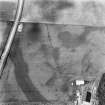
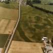
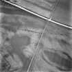
Two parallel lines, 20m apart. This feature seems to change direction at the NW and one line continues to the W (site 12 on map: fig. 1).

(Undated) information in NMRS.

The supposed prehistoric cursus was sectioned (NO02SE 35.01). It was found that there were three, rather than two, ditches. The largest, apparent on several aerial photographs, lay some 25m S of the two shallow N ditches which lay only 1m apart. All three ditches and the alluvium into which they were dug produced 14th and 15th century pottery; 20cm below the level through which the S ditch was cut, a pebbled surface 4m wide was located. It was bounded on the N by a shallow channel and on the S had been cut by the ditch of the 'cursus'. The pebbling was split in two by a 20cm step down from S to N which ran along the whole exposed length of the surface. Pottery similar to that found on the linear ditched site was recovered from above and below the pebbles.

G Barclay 1977.

These are probably field boundaries and drains.

Information from RCAHMS (OGS) 28 April 2008

Activities

Aerial Photography (1967)

Oblique aerial photographs by John Dewar in 1967.

Watching Brief (October 2007 - March 2008)

A Cultural Heritage Assessment was undertaken by CFA Archaeology to identify the potential impact of the proposed Almond Valley Village Materplan development. The assessment included a desk-based study and field reconnaissance survey. The assessment considered the likely effects on cultural heritage interests arising from the development of the proposed new village near Almondbank

CFA Archaeology (G. Mudie, S. Hickman) 2008

OASIS ID - cfaarcha1-267801

References

MyCanmore Image Contributions


Contribute an Image

MyCanmore Text Contributions