
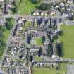
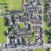
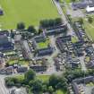
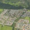
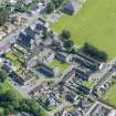
Menstrie, Castle Road, Menstrie Castle North Wing, 3 - 4 Castle Court


Fortified House (Period Unassigned), House(S) (Period Unassigned)
Site Name Menstrie, Castle Road, Menstrie Castle North Wing, 3 - 4 Castle Court
Classification Fortified House (Period Unassigned), House(S) (Period Unassigned)
Alternative Name(s) Menstrie Place
Canmore ID 268672
Site Number NS89NW 21.01
NGR NS 84940 96870
Datum OSGB36 - NGR
Permalink http://canmore.org.uk/site/268672


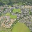
- Council Clackmannan
- Parish Alva
- Former Region Central
- Former District Clackmannan
- Former County Clackmannanshire
Photographic Survey (1956)
Photographic survey by the Scottish National Buildings Record in 1956.

