
Loudounhill Sand Quarry


Quarry (Period Unassigned)
Site Name Loudounhill Sand Quarry
Classification Quarry (Period Unassigned)
Canmore ID 268626
Site Number NS63NW 59
NGR NS 6061 3716
NGR Description Centred on NS 6061 3716
Datum OSGB36 - NGR
Permalink http://canmore.org.uk/site/268626


- Council East Ayrshire
- Parish Galston
- Former Region Strathclyde
- Former District Kilmarnock And Loudoun
- Former County Ayrshire
NS 618 365 (centre) Archaeological evaluation of 5% of a proposed quarry extension adjacent to Loudounhill Quarry was undertaken in August 2004. No artefacts or archaeological features were encountered.
Report lodged with WoSAS SMR and the NMRS.
Sponsor: Tarmac Northern Ltd.
J S Duncan 2004
NS63NW 59 centred on 6061 3716
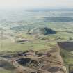
The sand and gravel quarry lies on a low ridge on the S side of the River Irvine and occupies the site of the destroyed Loudounhill Roman Fort (NS63NW1).
Information from RCAHMS (MMB) 26 February 2003

