
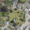
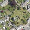
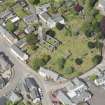
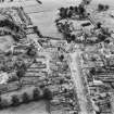
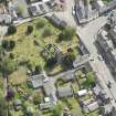
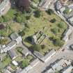
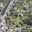
Muthill, Old Parish Church, Burial-ground


Burial Ground (Medieval), Churchyard (Post Medieval), Cobbled Road (Period Unknown)
Site Name Muthill, Old Parish Church, Burial-ground
Classification Burial Ground (Medieval), Churchyard (Post Medieval), Cobbled Road (Period Unknown)
Canmore ID 268492
Site Number NN81NE 3.02
NGR NN 86799 17058
Datum OSGB36 - NGR
Permalink http://canmore.org.uk/site/268492


- Council Perth And Kinross
- Parish Muthill
- Former Region Tayside
- Former District Perth And Kinross
- Former County Perthshire
Note (27 September 2024)
A churchyard and burial ground is depicted on the 1st edition of the OS 25-inch map (1865) - Perth and Clackmannanshire CVII.7 (Muthill).
Information from HES (D Watson) 26 September 2024

