
Pricing Change
New pricing for orders of material from this site will come into place shortly. Charges for supply of digital images, digitisation on demand, prints and licensing will be altered.
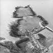
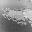
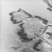
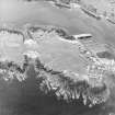
Isle Head


Rig And Furrow (Medieval) - (Post Medieval)
Site Name Isle Head
Classification Rig And Furrow (Medieval) - (Post Medieval)
Alternative Name(s) Isle Of Whithorn
Canmore ID 268354
Site Number NX43NE 88
NGR NX 4799 3612
NGR Description Centred on NX 4799 3612
Datum OSGB36 - NGR
Permalink http://canmore.org.uk/site/268354


- Council Dumfries And Galloway
- Parish Whithorn
- Former Region Dumfries And Galloway
- Former District Wigtown
- Former County Wigtownshire
NX43NE 88 centred on 4799 3612
There is a small block of rig on Isle Head, lying between the causeway leading to the promontory and the ramparts of a fort (NX43NE 8). The furrows, which are orientated from NE to SW across the promontory, are spaced about 5m apart at the NNW, with the rigs getting narrower to the SSE.
Information from RCAHMS (SMDG) 12 November 2004

