
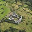
Edinburgh, Blackford Hill, Observatory Road, The Royal Observatory, Gate-lodge, Gates And Gate-piers


Gate(S) (19th Century), Gate Lodge (19th Century), Gate Pier(S) (19th Century)
Site Name Edinburgh, Blackford Hill, Observatory Road, The Royal Observatory, Gate-lodge, Gates And Gate-piers
Classification Gate(S) (19th Century), Gate Lodge (19th Century), Gate Pier(S) (19th Century)
Alternative Name(s) Royal Observatory Of Edinburgh
Canmore ID 268227
Site Number NT27SE 525.01
NGR NT 25905 70627
Datum OSGB36 - NGR
Permalink http://canmore.org.uk/site/268227


- Council Edinburgh, City Of
- Parish Edinburgh (Edinburgh, City Of)
- Former Region Lothian
- Former District City Of Edinburgh
- Former County Midlothian
NT27SE 525.01 25905 70627

