Accessibility

Font Size

100% 150% 200%

Background Colour

Default Contrast
Close Reset

West Huntingtower

Palisaded Enclosure (Period Unassigned)

Site Name West Huntingtower

Classification Palisaded Enclosure (Period Unassigned)

Alternative Name(s) Huntingtower Cropmark Complex

Canmore ID 26802

Site Number NO02NE 87

NGR NO 07702 25190

Datum OSGB36 - NGR

Permalink http://canmore.org.uk/site/26802

Ordnance Survey licence number AC0000807262. All rights reserved.
Canmore Disclaimer. © Bluesky International Limited 2025. Public Sector Viewing Terms

Toggle Aerial | View on large map

Digital Images

RCAHMSAP 77 (c079 250)
RCAHMSAP 77 (c079 250)Oblique aerial view.Oblique aerial view.Oblique aerial view.Oblique aerial view of Huntingtower Haugh centred on the cropmarks of an enclosure with cropmarks, rig, palisaded enclosure and Roman road adjacent, taken from the N.Oblique aerial view of Huntingtower Haugh centred on the cropmarks of an enclosure with cropmarks, rig, palisaded enclosure and Roman road adjacent, taken from the NW.Oblique aerial view.Oblique aerial view of West Huntingtower centred on the cropmarks of a palisaded enclosure with enclosure, cropmarks, rig and Roman road adjacent, taken from the NW.Oblique aerial view.Oblique aerial view of Huntingtower Haugh centred on the cropmarks of an enclosure with cropmarks, rig, palisaded enclosure and Roman road adjacent, taken from the NE.Oblique aerial view centred on the cropmarks of an enclosure and rig with enclosure, pit-circle, Roman Road, linear cropmarks and pits adjacent, taken from the W.Oblique aerial view.West Huntingtower, NO02NE 87, Ordnance Survey index card, page number 1, RectoOblique aerial view centred on the cropmarks of an enclosure, pit-circle, Roman Road, linear cropmarks, pits and pit-alignment, taken from the ENE.Oblique aerial view of Huntingtower Haugh centred on the cropmarks of an enclosure with cropmarks, rig, palisaded enclosure and Roman road adjacent, taken from the SW.Oblique aerial view.Oblique aerial view.RCAHMSAP 77 (c079 250)Oblique aerial view.Oblique aerial view.Oblique aerial view of Huntingtower Haugh centred on the cropmarks of an enclosure with cropmarks, rig, palisaded enclosure and Roman road adjacent, taken from the S.Oblique aerial view of Huntingtower Haugh centred on the cropmarks of an enclosure with cropmarks, rig, palisaded enclosure and Roman road adjacent, taken from the N.Oblique aerial view.Oblique aerial view.Oblique aerial view centred on the cropmarks of an enclosure and rig with Roman Road, linear cropmarks and pits adjacent, taken from the NW.Oblique aerial view of Huntingtower Haugh centred on the cropmarks of an enclosure with cropmarks, rig, palisaded enclosure and Roman road adjacent, taken from the NW.Oblique aerial view.Oblique aerial view centred on the cropmarks of an enclosure, Roman Road and rig with enclosure and pit-circle adjacent, taken from the SW.Oblique aerial view centred on the cropmarks of an enclosure, Roman Road and rig with linear cropmarks adjacent, taken from the SSW.Oblique aerial view.Oblique aerial view.Oblique aerial view.West Huntingtower, NO02NE 87, Ordnance Survey index card, page number 2, Recto

Administrative Areas

  • Council Perth And Kinross
  • Parish Tibbermore
  • Former Region Tayside
  • Former District Perth And Kinross
  • Former County Perthshire

Archaeology Notes

NO02NE 87 07702 25190

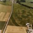
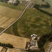
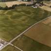
For other elements of the Mains of Huntingtower cropmark complex, see NO02NE 39, NO02NE 86, NO02NE 100, NO02NE 151, NO02SE 27, NO02SE 49, NO02SE 66 and NO02SE 67.

A small circular enclosure straddling a field boundary. Possible entrance on the east. Narrow ditch. (Site 7 in Barclay 1983).

(Undated) information in NMRS.

Scheduled as [part of] 'Mains of Huntingtower, henges, enclosures, pits and road WSW of... the remains of a neolithic henge, two prehistoric enclosures, five prehistoric roundhouses, dispersed groups of pits and a broadly-parallel alignment of pits representing a Roman road [surviving] as a complex group of buried archaeological features... on a river terrace in cultivated land to the north-west of Perth, 1km south of the River Almond and at 35m above sea level.'

Information from Historic Scotland, scheduling document dated 25 November 2008.

Activities

Watching Brief (6 July 2010)

NO 0810 2510 A watching brief and metal detector survey

were undertaken on 6 July 2010 during groundbreaking

works associated with the installation of a septic tank and

related features (including tailrace and soakaway). Part

of these works crossed the eastern end of a scheduled

monument (AMH 3630 – Mains of Huntingtower, henge,

enclosure pits and road WSW of), but no features or deposits

of archaeological significance were recorded.

Archive: RCAHMS. Report: Historic Scotland and Perth and Kinross

Heritage Trust

Funder: Mr J Ritchie

References

MyCanmore Image Contributions


Contribute an Image

MyCanmore Text Contributions