
Following the launch of trove.scot in February 2025 we are now planning the retiral of some of our webservices. Canmore will be switched off on 24th June 2025. Information about the closure can be found on the HES website: Retiral of HES web services | Historic Environment Scotland
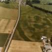
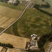
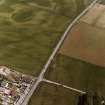
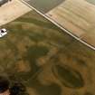
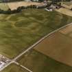
Huntingtower Haugh


Cropmark(S) (Period Unknown), Rig And Furrow (Medieval) - (Post Medieval)
Site Name Huntingtower Haugh
Classification Cropmark(S) (Period Unknown), Rig And Furrow (Medieval) - (Post Medieval)
Alternative Name(s) Huntingtower Haugh 3
Canmore ID 26800
Site Number NO02NE 85
NGR NO 07731 25083
Datum OSGB36 - NGR
Permalink http://canmore.org.uk/site/26800


- Council Perth And Kinross
- Parish Tibbermore
- Former Region Tayside
- Former District Perth And Kinross
- Former County Perthshire
NO02NE 85 07731 25083
A series of ill-defined features are visible on APs in this area around the 'enclosure' NO02NE 71. They could represent an unenclosed settlement or alternatively they may be periglacial in origin.
(Undated) information in NMRS.

