
Following the launch of trove.scot in February 2025 we are now planning the retiral of some of our webservices. Canmore will be switched off on 24th June 2025. Information about the closure can be found on the HES website: Retiral of HES web services | Historic Environment Scotland
Inverkeithing, Hillend Road, Inverkeithing High School (General)


School (20th Century)
Site Name Inverkeithing, Hillend Road, Inverkeithing High School (General)
Classification School (20th Century)
Canmore ID 267922
Site Number NT18SW 331
NGR NT 13683 83448
Datum OSGB36 - NGR
Permalink http://canmore.org.uk/site/267922
Ordnance Survey licence number AC0000807262. All rights reserved.
Canmore Disclaimer.
© Bluesky International Limited 2025. Public Sector Viewing Terms
- Correction
- Favourite

DP 208338
View towards main entrance from sw.
Records of the Royal Commission on the Ancient and Historical Monuments of Scotland (RCAHMS), Edinbu
18/2/2015
© Crown Copyright: HES

DP 208341
View of admin block and main entrance from ne.
Records of the Royal Commission on the Ancient and Historical Monuments of Scotland (RCAHMS), Edinbu
18/2/2015
© Crown Copyright: HES

DP 208351
Home economics block and linking bridge from north east.
Records of the Royal Commission on the Ancient and Historical Monuments of Scotland (RCAHMS), Edinbu
18/2/2015
© Crown Copyright: HES

DP 208352
View of main block from east.
Records of the Royal Commission on the Ancient and Historical Monuments of Scotland (RCAHMS), Edinbu
18/2/2015
© Crown Copyright: HES

DP 208353
View of middle linking bridge with vehicle access from south east.
Records of the Royal Commission on the Ancient and Historical Monuments of Scotland (RCAHMS), Edinbu
18/2/2015
© Crown Copyright: HES

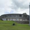
DP 221457
General view of C Block from south west.
Records of the Royal Commission on the Ancient and Historical Monuments of Scotland (RCAHMS), Edinbu
25/7/2015
© Crown Copyright: HES

DP 225638
C Block, detail of collage.
Records of the Royal Commission on the Ancient and Historical Monuments of Scotland (RCAHMS), Edinbu
25/7/2015
© Crown Copyright: HES

DP 225640
C Block, detail of collage.
Records of the Royal Commission on the Ancient and Historical Monuments of Scotland (RCAHMS), Edinbu
25/7/2015
© Crown Copyright: HES

DP 225643
A block, general view of stage in assembly hall, from east.
Records of the Royal Commission on the Ancient and Historical Monuments of Scotland (RCAHMS), Edinbu
25/7/2015
© Crown Copyright: HES

DP 225653
C Block, roof level general view of C301 from south.
Records of the Royal Commission on the Ancient and Historical Monuments of Scotland (RCAHMS), Edinbu
25/7/2015
© Crown Copyright: HES

DP 225669
S Block, view of classroom from east.
Records of the Royal Commission on the Ancient and Historical Monuments of Scotland (RCAHMS), Edinbu
25/7/2015
© Crown Copyright: HES

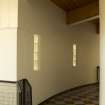
DP 225670
S Block, view in circular corridor from south.
Records of the Royal Commission on the Ancient and Historical Monuments of Scotland (RCAHMS), Edinbu
25/7/2015
© Crown Copyright: HES

DP 225679
C Block, second floor view of classroom fro north.
Records of the Royal Commission on the Ancient and Historical Monuments of Scotland (RCAHMS), Edinbu
25/7/2015
© Crown Copyright: HES

DP 225681
C Block, first floor C105 lower level, originally the library. View from north.
Records of the Royal Commission on the Ancient and Historical Monuments of Scotland (RCAHMS), Edinbu
25/7/2015
© Crown Copyright: HES

DP 225692
S Block, Lecture theatre, view from north.
Records of the Royal Commission on the Ancient and Historical Monuments of Scotland (RCAHMS), Edinbu
25/7/2015
© Crown Copyright: HES

DP 225694
S Block, lecture theatre view from east.
Records of the Royal Commission on the Ancient and Historical Monuments of Scotland (RCAHMS), Edinbu
25/7/2015
© Crown Copyright: HES

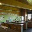
DP 225698
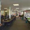
H Block, view of library from north.
Records of the Royal Commission on the Ancient and Historical Monuments of Scotland (RCAHMS), Edinbu
25/7/2015
© Crown Copyright: HES

DP 225719
G Block, detail of handrail around seating area.
Records of the Royal Commission on the Ancient and Historical Monuments of Scotland (RCAHMS), Edinbu
25/7/2015
© Crown Copyright: HES

DP 208342
View from south to bridge, linking geography dept to south round block - home economics
Records of the Royal Commission on the Ancient and Historical Monuments of Scotland (RCAHMS), Edinbu
18/2/2015
© Crown Copyright: HES

DP 208349
Detail of home economic ( south round block)
Records of the Royal Commission on the Ancient and Historical Monuments of Scotland (RCAHMS), Edinbu
18/2/2015
© Crown Copyright: HES

DP 208359
View of north bridge from south west.
Records of the Royal Commission on the Ancient and Historical Monuments of Scotland (RCAHMS), Edinbu
18/2/2015
© Crown Copyright: HES

DP 208362
View along walkway on ground level of main block from north, showing timber cladding.
Records of the Royal Commission on the Ancient and Historical Monuments of Scotland (RCAHMS), Edinbu
18/2/2015
© Crown Copyright: HES

DP 208364
View of main block and assembly hall from north west.
Records of the Royal Commission on the Ancient and Historical Monuments of Scotland (RCAHMS), Edinbu
18/2/2015
© Crown Copyright: HES

DP 208366
View of technical block from south west.
Records of the Royal Commission on the Ancient and Historical Monuments of Scotland (RCAHMS), Edinbu
18/2/2015
© Crown Copyright: HES

DP 208369
Distant view of technical block and language dept from south.
Records of the Royal Commission on the Ancient and Historical Monuments of Scotland (RCAHMS), Edinbu
18/2/2015
© Crown Copyright: HES

DP 221441
View of home economics block to the south east, from roof of c-block
Records of the Royal Commission on the Ancient and Historical Monuments of Scotland (RCAHMS), Edinbu
25/7/2015
© Crown Copyright: HES

DP 221442
View of lift shaft on c-block from south.
Records of the Royal Commission on the Ancient and Historical Monuments of Scotland (RCAHMS), Edinbu
25/7/2015
© Crown Copyright: HES

DP 221445
View of dining hall 1 in A-block from south west.
Records of the Royal Commission on the Ancient and Historical Monuments of Scotland (RCAHMS), Edinbu
25/7/2015
© Crown Copyright: HES

DP 225642
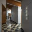
A Block, view into main entrance in C Block, from west.
Records of the Royal Commission on the Ancient and Historical Monuments of Scotland (RCAHMS), Edinbu
25/7/2015
© Crown Copyright: HES

DP 225648
A block, assembly hall, detail of mural.
Records of the Royal Commission on the Ancient and Historical Monuments of Scotland (RCAHMS), Edinbu
25/7/2015
© Crown Copyright: HES

DP 225656
C Block, roof level art block, interior view from north.
Records of the Royal Commission on the Ancient and Historical Monuments of Scotland (RCAHMS), Edinbu
25/7/2015
© Crown Copyright: HES

DP 225658
C Block, roof level art block, interior view from north.
Records of the Royal Commission on the Ancient and Historical Monuments of Scotland (RCAHMS), Edinbu
25/7/2015
© Crown Copyright: HES

DP 225673
C Block, roof level, general view of music room
Records of the Royal Commission on the Ancient and Historical Monuments of Scotland (RCAHMS), Edinbu
25/7/2015
© Crown Copyright: HES

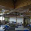
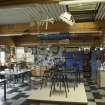
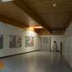
DP 225685
H Block, view of dining hall from west.
Records of the Royal Commission on the Ancient and Historical Monuments of Scotland (RCAHMS), Edinbu
25/7/2015
© Crown Copyright: HES

DP 225686
H Block, view of dining hall from west.
Records of the Royal Commission on the Ancient and Historical Monuments of Scotland (RCAHMS), Edinbu
25/7/2015
© Crown Copyright: HES

DP 225689
H Block, detail of dining hall ceiling. Inverkeithing High School.
Records of the Royal Commission on the Ancient and Historical Monuments of Scotland (RCAHMS), Edinbu
25/7/2015
© Crown Copyright: HES

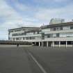
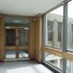
DP 208346
View of main entrance, admin and dining blocks, from east.
Records of the Royal Commission on the Ancient and Historical Monuments of Scotland (RCAHMS), Edinbu
18/2/2015
© Crown Copyright: HES

DP 208354
View from south east to north linking bridge.
Records of the Royal Commission on the Ancient and Historical Monuments of Scotland (RCAHMS), Edinbu
18/2/2015
© Crown Copyright: HES

DP 208358
View of middle linking bridge to main block from north east.
Records of the Royal Commission on the Ancient and Historical Monuments of Scotland (RCAHMS), Edinbu
18/2/2015
© Crown Copyright: HES

DP 208365
View of north face and staicase of assembly hall from north east.
Records of the Royal Commission on the Ancient and Historical Monuments of Scotland (RCAHMS), Edinbu
18/2/2015
© Crown Copyright: HES

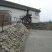
DP 221448
View of main entrance from south east.
Records of the Royal Commission on the Ancient and Historical Monuments of Scotland (RCAHMS), Edinbu
25/7/2015
© Crown Copyright: HES

DP 221452
View of end elevation of C-block from north.
Records of the Royal Commission on the Ancient and Historical Monuments of Scotland (RCAHMS), Edinbu
25/7/2015
© Crown Copyright: HES

DP 221458
View of C Block and Assembly Hall from north west.
Records of the Royal Commission on the Ancient and Historical Monuments of Scotland (RCAHMS), Edinbu
25/7/2015
© Crown Copyright: HES

DP 225636
C Block, split level main entrance area, view from east.
Records of the Royal Commission on the Ancient and Historical Monuments of Scotland (RCAHMS), Edinbu
25/7/2015
© Crown Copyright: HES

DP 225645
A Block, assembly hall, detail of steps to gallery from north west.
Records of the Royal Commission on the Ancient and Historical Monuments of Scotland (RCAHMS), Edinbu
25/7/2015
© Crown Copyright: HES

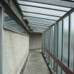
DP 225650
C Block, first floor, view of bridge walkway to A block from east.
Records of the Royal Commission on the Ancient and Historical Monuments of Scotland (RCAHMS), Edinbu
25/7/2015
© Crown Copyright: HES

DP 225654
C Block, roof. View along walkway from south.
Records of the Royal Commission on the Ancient and Historical Monuments of Scotland (RCAHMS), Edinbu
25/7/2015
© Crown Copyright: HES

DP 225660
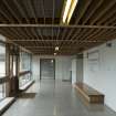
C Block, first floor. Classroom C217 & C219 with partition open.
Records of the Royal Commission on the Ancient and Historical Monuments of Scotland (RCAHMS), Edinbu
25/7/2015
© Crown Copyright: HES

DP 225661
C Block, first floor. Classroom C217 & C219 with partition closed
Records of the Royal Commission on the Ancient and Historical Monuments of Scotland (RCAHMS), Edinbu
25/7/2015
© Crown Copyright: HES

DP 225666
C Block, view of entrance to S block, from south west.
Records of the Royal Commission on the Ancient and Historical Monuments of Scotland (RCAHMS), Edinbu
25/7/2015
© Crown Copyright: HES

DP 225667
S Block, view of entrance lobby from south west.
Records of the Royal Commission on the Ancient and Historical Monuments of Scotland (RCAHMS), Edinbu
25/7/2015
© Crown Copyright: HES

DP 225674
C Block, roof level. View of corridor in music block.
Records of the Royal Commission on the Ancient and Historical Monuments of Scotland (RCAHMS), Edinbu
25/7/2015
© Crown Copyright: HES

DP 225678
C Block, second floor main corridor. Detail of glazing to room 105.
Records of the Royal Commission on the Ancient and Historical Monuments of Scotland (RCAHMS), Edinbu
25/7/2015
© Crown Copyright: HES

DP 225680
C Block, second floor C105 upper level, originally the library. View from south.
Records of the Royal Commission on the Ancient and Historical Monuments of Scotland (RCAHMS), Edinbu
25/7/2015
© Crown Copyright: HES

DP 208347
View from south east towards south linking bridge.
Records of the Royal Commission on the Ancient and Historical Monuments of Scotland (RCAHMS), Edinbu
18/2/2015
© Crown Copyright: HES

DP 208363
View of west facade of main block from basketball court, north west.
Records of the Royal Commission on the Ancient and Historical Monuments of Scotland (RCAHMS), Edinbu
18/2/2015
© Crown Copyright: HES

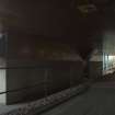
DP 208447
View of underpass from main entrance at west.
Records of the Royal Commission on the Ancient and Historical Monuments of Scotland (RCAHMS), Edinbu
18/2/2015
© Crown Copyright: HES

DP 208456
View of covered recreation area linking main block with technical block, from south.
Records of the Royal Commission on the Ancient and Historical Monuments of Scotland (RCAHMS), Edinbu
18/2/2015
© Crown Copyright: HES

DP 221444
View of lift shaft of c-block from north.
Records of the Royal Commission on the Ancient and Historical Monuments of Scotland (RCAHMS), Edinbu
25/7/2015
© Crown Copyright: HES

DP 221450
General view of C-block from east.
Records of the Royal Commission on the Ancient and Historical Monuments of Scotland (RCAHMS), Edinbu
25/7/2015
© Crown Copyright: HES

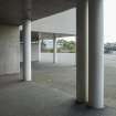
DP 221455
Detail of piloti on west side of C Block.
Records of the Royal Commission on the Ancient and Historical Monuments of Scotland (RCAHMS), Edinbu
25/7/2015
© Crown Copyright: HES

DP 225637
C Block, main entrance, view of fibre-glass collage from south.
Records of the Royal Commission on the Ancient and Historical Monuments of Scotland (RCAHMS), Edinbu
25/7/2015
© Crown Copyright: HES

DP 225644
A block, assembly hall, general view from south west.
Records of the Royal Commission on the Ancient and Historical Monuments of Scotland (RCAHMS), Edinbu
25/7/2015
© Crown Copyright: HES

DP 225647
A block, assembly hall view from north east.
Records of the Royal Commission on the Ancient and Historical Monuments of Scotland (RCAHMS), Edinbu
25/7/2015
© Crown Copyright: HES

DP 225663
C Block first floor. Detail of display cabinet beside central stair.
Records of the Royal Commission on the Ancient and Historical Monuments of Scotland (RCAHMS), Edinbu
25/7/2015
© Crown Copyright: HES

DP 225664
C Block, first floor. View of C216 from south east.
Records of the Royal Commission on the Ancient and Historical Monuments of Scotland (RCAHMS), Edinbu
25/7/2015
© Crown Copyright: HES

DP 225668
S Block, view of classroom from west.
Records of the Royal Commission on the Ancient and Historical Monuments of Scotland (RCAHMS), Edinbu
25/7/2015
© Crown Copyright: HES

DP 225684
H Block, entrance, view from west.
Records of the Royal Commission on the Ancient and Historical Monuments of Scotland (RCAHMS), Edinbu
25/7/2015
© Crown Copyright: HES

DP 225706
C Block, South entrance area from east.
Records of the Royal Commission on the Ancient and Historical Monuments of Scotland (RCAHMS), Edinbu
25/7/2015
© Crown Copyright: HES

DP 225713
G Block, view of sunken seating area from east.
Records of the Royal Commission on the Ancient and Historical Monuments of Scotland (RCAHMS), Edinbu
25/7/2015
© Crown Copyright: HES

DP 225714
G Block, view of reacreational space from west.
Records of the Royal Commission on the Ancient and Historical Monuments of Scotland (RCAHMS), Edinbu
25/7/2015
© Crown Copyright: HES

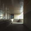
DP 225722
T Block, view of covered area at basement level of C Block from entrance to T Block.
Records of the Royal Commission on the Ancient and Historical Monuments of Scotland (RCAHMS), Edinbu
25/7/2015
© Crown Copyright: HES

DP 208344
View from west, up steps to south round block.
Records of the Royal Commission on the Ancient and Historical Monuments of Scotland (RCAHMS), Edinbu
18/2/2015
© Crown Copyright: HES

DP 221449
View of main entrance from south east.
Records of the Royal Commission on the Ancient and Historical Monuments of Scotland (RCAHMS), Edinbu
25/7/2015
© Crown Copyright: HES

DP 221453
View of science, S-block, from north.
Records of the Royal Commission on the Ancient and Historical Monuments of Scotland (RCAHMS), Edinbu
25/7/2015
© Crown Copyright: HES

DP 221461
Detail of nursery signage.
Records of the Royal Commission on the Ancient and Historical Monuments of Scotland (RCAHMS), Edinbu
25/7/2015
© Crown Copyright: HES

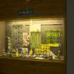
DP 225639
C Block, detail of collage guide.
Records of the Royal Commission on the Ancient and Historical Monuments of Scotland (RCAHMS), Edinbu
25/7/2015
© Crown Copyright: HES

DP 225687
H Block, view of classroom from south.
Records of the Royal Commission on the Ancient and Historical Monuments of Scotland (RCAHMS), Edinbu
25/7/2015
© Crown Copyright: HES

DP 225696
S Block, lecture theatre detail of ceiling.
Records of the Royal Commission on the Ancient and Historical Monuments of Scotland (RCAHMS), Edinbu
25/7/2015
© Crown Copyright: HES

DP 225718
G Block, detail of handrail around seating area.
Records of the Royal Commission on the Ancient and Historical Monuments of Scotland (RCAHMS), Edinbu
25/7/2015
© Crown Copyright: HES

DP 225721
C Block, basement level, detail of piloti at north corridor.
Records of the Royal Commission on the Ancient and Historical Monuments of Scotland (RCAHMS), Edinbu
25/7/2015
© Crown Copyright: HES

DP 225723
G Block, view of recreational space from north east.
Records of the Royal Commission on the Ancient and Historical Monuments of Scotland (RCAHMS), Edinbu
25/7/2015
© Crown Copyright: HES

DP 208343
View from south to bridge, linking geography dept to south round block - home economics
Records of the Royal Commission on the Ancient and Historical Monuments of Scotland (RCAHMS), Edinbu
18/2/2015
© Crown Copyright: HES

DP 208348
Detail of home economic ( south round block)
Records of the Royal Commission on the Ancient and Historical Monuments of Scotland (RCAHMS), Edinbu
18/2/2015
© Crown Copyright: HES

DP 208350
View from east of home economics block and road to overflow caroark.
Records of the Royal Commission on the Ancient and Historical Monuments of Scotland (RCAHMS), Edinbu
18/2/2015
© Crown Copyright: HES

DP 208361
View of science block and north bridge from south west.
Records of the Royal Commission on the Ancient and Historical Monuments of Scotland (RCAHMS), Edinbu
18/2/2015
© Crown Copyright: HES

DP 221440
View along rooftop walkway from south.
Records of the Royal Commission on the Ancient and Historical Monuments of Scotland (RCAHMS), Edinbu
25/7/2015
© Crown Copyright: HES

DP 221447
View of home economics, H-block, from south west.
Records of the Royal Commission on the Ancient and Historical Monuments of Scotland (RCAHMS), Edinbu
25/7/2015
© Crown Copyright: HES

DP 221451
View along entrance to C-clock on third floor, from east.
Records of the Royal Commission on the Ancient and Historical Monuments of Scotland (RCAHMS), Edinbu
25/7/2015
© Crown Copyright: HES

DP 221460
View of nursery block from north east.
Records of the Royal Commission on the Ancient and Historical Monuments of Scotland (RCAHMS), Edinbu
25/7/2015
© Crown Copyright: HES

DP 225641
A Block, view into main entrance in C Block, from west.
Records of the Royal Commission on the Ancient and Historical Monuments of Scotland (RCAHMS), Edinbu
25/7/2015
© Crown Copyright: HES

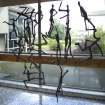
DP 225649
C Block, main entrance, detail of A.Giametti inspired sculpture.
Records of the Royal Commission on the Ancient and Historical Monuments of Scotland (RCAHMS), Edinbu
25/7/2015
© Crown Copyright: HES

DP 225672
S Block, general view of classroom from north.
Records of the Royal Commission on the Ancient and Historical Monuments of Scotland (RCAHMS), Edinbu
25/7/2015
© Crown Copyright: HES

DP 225676
C Block, second floor. General view of stairway with black glazing to music department.
Records of the Royal Commission on the Ancient and Historical Monuments of Scotland (RCAHMS), Edinbu
25/7/2015
© Crown Copyright: HES

DP 225677
C Block, second floor, view along main corridor from south.
Records of the Royal Commission on the Ancient and Historical Monuments of Scotland (RCAHMS), Edinbu
25/7/2015
© Crown Copyright: HES

DP 225683
C Block, first floor. View along corridor from south.
Records of the Royal Commission on the Ancient and Historical Monuments of Scotland (RCAHMS), Edinbu
25/7/2015
© Crown Copyright: HES

DP 225690
H Block, view of doorway to C block.
Records of the Royal Commission on the Ancient and Historical Monuments of Scotland (RCAHMS), Edinbu
25/7/2015
© Crown Copyright: HES

DP 225697
S Block, view of round corridor from north.
Records of the Royal Commission on the Ancient and Historical Monuments of Scotland (RCAHMS), Edinbu
25/7/2015
© Crown Copyright: HES

DP 225704
T Block, Entrance, view from south.
Records of the Royal Commission on the Ancient and Historical Monuments of Scotland (RCAHMS), Edinbu
25/7/2015
© Crown Copyright: HES

DP 225710
A Block, reception. Details of boards.
Records of the Royal Commission on the Ancient and Historical Monuments of Scotland (RCAHMS), Edinbu
25/7/2015
© Crown Copyright: HES


First 100 images shown. See the Collections panel (below) for a link to all digital images.
- Council Fife
- Parish Inverkeithing
- Former Region Fife
- Former District Dunfermline
- Former County Fife
NT18SW 331.00 13683 83448
NT18SW 331.01 13692 83492 Administration Block
NT18SW 331.02 13687 83390 Art Block
NT18SW 331.03 13662 83493 Technical Block
NT18SW 331.04 13792 83480 NE Pavilion
NT18SW 331.05 13729 83391 SE Pavilion
NT18SW 331.06 13584 83450 Gymnasium and Community Centre

