
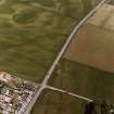
Huntingtower Haugh


Enclosure (Period Unassigned)(Possible)
Site Name Huntingtower Haugh
Classification Enclosure (Period Unassigned)(Possible)
Alternative Name(s) Huntingtower Haugh 2
Canmore ID 26784
Site Number NO02NE 71
NGR NO 07810 25115
Datum OSGB36 - NGR
Permalink http://canmore.org.uk/site/26784


- Council Perth And Kinross
- Parish Tibbermore
- Former Region Tayside
- Former District Perth And Kinross
- Former County Perthshire
NO02NE 71 07810 25115
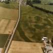
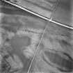
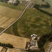
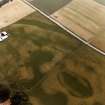
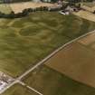
Probably natural. APs show an elongated oval enclosure, orientated E-W with opposing 'entrances' on the N and S sides. The edges of the cropmark are poorly defined and it seems likely that this is a natural, glacial feature.
(Undated) information in NMRS.

