
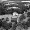
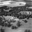
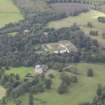
Oxenfoord Castle, Walled Garden


Walled Garden (Period Unassigned)
Site Name Oxenfoord Castle, Walled Garden
Classification Walled Garden (Period Unassigned)
Canmore ID 267838
Site Number NT36NE 62.09
NGR NT 38646 65614
NGR Description Centred on NT 38646 65614
Datum OSGB36 - NGR
Permalink http://canmore.org.uk/site/267838


- Council Midlothian
- Parish Cranston
- Former Region Lothian
- Former District Midlothian
- Former County Midlothian

