
Ruthvenfield House, Huntingtower


Formal Garden (Period Unassigned)
Site Name Ruthvenfield House, Huntingtower
Classification Formal Garden (Period Unassigned)
Alternative Name(s) Ruthvenfield House, Huntingtower 2
Canmore ID 26771
Site Number NO02NE 59
NGR NO 08607 25439
NGR Description NO 085 252 to NN 086 255
Datum OSGB36 - NGR
Permalink http://canmore.org.uk/site/26771


- Council Perth And Kinross
- Parish Tibbermore
- Former Region Tayside
- Former District Perth And Kinross
- Former County Perthshire
NO02NE 59 085 252 to 086 255
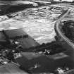
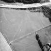
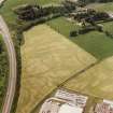
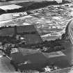
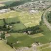
This cropmark consisting of two parallel lines some distance apart with circular features at the ends and in the middle. The most likely interpretation would seem to be a plantation bank.
(Undated) information from NMRS record card.
Watching Brief (October 2007 - March 2008)
A Cultural Heritage Assessment was undertaken by CFA Archaeology to identify the potential impact of the proposed Almond Valley Village Materplan development. The assessment included a desk-based study and field reconnaissance survey. The assessment considered the likely effects on cultural heritage interests arising from the development of the proposed new village near Almondbank
CFA Archaeology (G. Mudie, S. Hickman) 2008
OASIS ID - cfaarcha1-267801

