
Ness Of Brodgar


Drain (Period Unassigned)(Possible), Enclosure (Period Unassigned)(Possible)
Site Name Ness Of Brodgar
Classification Drain (Period Unassigned)(Possible), Enclosure (Period Unassigned)(Possible)
Canmore ID 267574
Site Number HY21SE 89
NGR HY 29068 13237
Datum OSGB36 - NGR
Permalink http://canmore.org.uk/site/267574


- Council Orkney Islands
- Parish Stenness
- Former Region Orkney Islands Area
- Former District Orkney
- Former County Orkney
HY21SE 89 HY 29068 13237
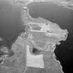
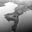
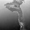
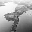
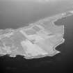
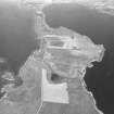
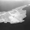
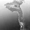
A possible drain or part of an enclosure is visible as a cropmark on oblique aerial photographs (RCAHMSAP 1977) of the Ring of Brodgar (HY21SE 1). The cropmark describes a rough L-shape, extending for some 25m SW-NE from the eroding shoreline along the NE side of the Loch of Stenness, before turning at a right angle to run for about 30m SE to NW. At the point where the ditch meets the small cliff on the shoreline two light patches can be seen on one of the photographs (O1568), apparently extending the line of the ditch. These may be an eroding feature associated with the ditch, perhaps a stone lining. What may be a natural drainage line runs past the NW end of the ditch extending from a small pond to the E to the Loch of Stenness. The pond is probably seasonal as it is not visible on the photographs, but is depicted on OS mapping from the 1st edition of the OS 6-inch map (1882) to the most recent edition of the 1:10,000 map (1971).
Information from RCAHMS (SMDG) 29 October 2004
Aerial Photographic Interpretation (2004 - 2005)
HY 2905 1322 Cropmark A linear feature is visible on oblique photographs taken by John Dewar in 1977 (O/1568). The feature turns at its mid-point and appears to form part of a sub-square enclosure. A site visit revealed this to be caused by a field drain.
Dissertation: Orkney College, UHIMI
Peter Leeming – Orkney College

