
Machrihanish, Intermediate Ground Control Intercept Radar Station


Radar Station (20th Century)
Site Name Machrihanish, Intermediate Ground Control Intercept Radar Station
Classification Radar Station (20th Century)
Alternative Name(s) Loch Sanish; Bruntholme
Canmore ID 267562
Site Number NR62SE 34
NGR NR 6692 2041
Datum OSGB36 - NGR
Permalink http://canmore.org.uk/site/267562


- Council Argyll And Bute
- Parish Campbeltown
- Former Region Strathclyde
- Former District Argyll And Bute
- Former County Argyll
NR62SE 34 6692 2041
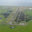
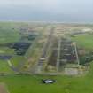
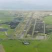
A Royal Navy Intermediate Ground Control Intercept (GCI) station has been identified from RAF vertical air photographs (106G/Scot/UK157, 3134-3135, 4118, flown 20 August 1946), in the centre of a field about 500m NW of Bruntholme (NR 6717 2000).
Visible on the photographs are three roofed buildings (one large and two small huts) in line from NE to SW, with what may be the aerial at the NE end.
Information from RCAHMS (DE), October 2004.

