
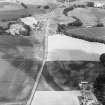
Mains Of Huntingtower


Cropmark(S) (Period Unknown), Enclosure (Period Unassigned), Four Poster Stone Circle (Bronze Age)(Possible), Pit(S) (Period Unassigned), Pit Circle (Prehistoric)
Site Name Mains Of Huntingtower
Classification Cropmark(S) (Period Unknown), Enclosure (Period Unassigned), Four Poster Stone Circle (Bronze Age)(Possible), Pit(S) (Period Unassigned), Pit Circle (Prehistoric)
Alternative Name(s) Mains Of Huntingtower 1; Huntingtower Cropmark Complex
Canmore ID 26749
Site Number NO02NE 39
NGR NO 07951 25191
Datum OSGB36 - NGR
Permalink http://canmore.org.uk/site/26749


- Council Perth And Kinross
- Parish Tibbermore
- Former Region Tayside
- Former District Perth And Kinross
- Former County Perthshire
NO02NE 39 079 251
For other elements of the Mains of Huntingtower cropmark complex, see NO02NE 86, NO02NE 87, NO02NE 100, NO02NE 151, NO02SE 27, NO02SE 49, NO02SE 66 and NO02SE 67.
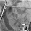
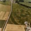
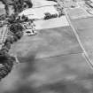
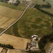
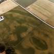
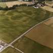
A large, roughly circular enclosure is located to the west of the farm of Mains of Huntingtower. There may be a concentric ring of 8 pits in the middle, c10m in diameter. There is no obvious entrance to the enclosure. A small, dark circular feature seems to overlap the enclosure on the west. Running through the enclosure is a dark linear feature forming an irregular enclosure from the edge of the escarpment to the farm. On the south the feature runs in the middle of the Roman Road line (Sites 5 and 6 in Barclay 1983).
G J Barclay 1983.
Scheduled as [part of] 'Mains of Huntingtower, henges, enclosures, pits and road WSW of... the remains of a neolithic henge, two prehistoric enclosures, five prehistoric roundhouses, dispersed groups of pits and a broadly-parallel alignment of pits representing a Roman road [surviving] as a complex group of buried archaeological features... on a river terrace in cultivated land to the north-west of Perth, 1km south of the River Almond and at 35m above sea level.'
Information from Historic Scotland, scheduling document dated 25 November 2008.

