
Camelon - Ardoch - Strageath - Cargill Roman Road


Roman Road (Roman)
Site Name Camelon - Ardoch - Strageath - Cargill Roman Road
Classification Roman Road (Roman)
Alternative Name(s) Rr 9b; Gask Ridge; Huntingtower Cropmark Complex
Canmore ID 26716
Site Number NO02NE 151
NGR NO 07971 25045
NGR Description NO 0807 2500 to NO 0999 2709
Datum OSGB36 - NGR
Permalink http://canmore.org.uk/site/26716


- Council Perth And Kinross
- Parish Tibbermore
- Former Region Tayside
- Former District Perth And Kinross
- Former County Perthshire
NO02NE 151 0807 2500 to 0999 2709
For other elements of the Mains of Huntingtower cropmark complex, see NO02NE 39, NO02NE 86, NO02NE 87, NO02NE 100, NO02SE 27, NO02SE 49, NO02SE 66 and NO02SE 67.
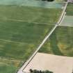
NO 0807 2500 to NO 0813 2503 The course is shown on OS Record 6 inch map (Crawford).
There is no trace of the road (WDJ).
NO 0835 2552 to NO 0877 2600 There is no trace of the road (JTT).
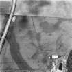
NO 0875 2598 to NO 0885 2606 A dark double cropmark line is visible in Bradley's photographs (photo 13, 1941).
NO 0877 2600 to NO 0909 2624 Course as seen from air and ground in 1941 (Bradley 1941)
There is no trace of the road (JTT).
NO 0892 2614 Ridge (Bradley 1941).
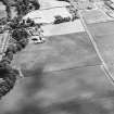
NO 0968 2686 The track of the Military Way indicated by an arable mound known as the Causewayridge skirts the northern boundary of the camp (NO02NE 25) (Maitland 1757).
NO 0968 2686 to NO 0982 2696 A dark linear cropmark similar in appearance to the cropmark E of the Tay (NO 0997 2707 to 0999 2709). See RAF vertical aerial photographs (F.21.58/1773, frame no 0017-8, 1955).
A low, spread mound across pasture field (JTT).
NO 0997 2707 to 0999 2709 A dark linear cropmark (continues into NO12NWxx at NO 1000 2709 to NO 1032 2753). See RAF vertical aerial photographs (F.21.58/1773, frame no 0017-8, 1955).
Alternative possibilities:
NO 0839 2553 to NO 0868 2560 Course shown on OS Record 6 inch map (Crawford). Probably based on Bradley's photographs (photos 9, 10, 23). Not convincing.
NO 0876 2600 to NO 0910 2626 and NO 0935 2637 to NO 0999 2665 Course as seen from air and ground in 1941 (Bradley 1941).
No trace of the road (JTT).
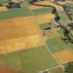
NO 0943 2673 to NO 0952 2708 Of the road on the W side there is only a doubtful trace, plainly seen on an aerial photograph as a dark band (Crawford 1949).
See RAF vertical aerial photographs (106G/ SCOT/ UK33, frame no 3127-8, 1946.).
There is no trace of the road (JTT).
NO 0955 2727 to NO 0957 2734 A dark linear cropmark is seen on RAF vertical aerial photographs (F.21.58/1773, frame no 0017-8, 1955).
NO c. 0957 2734 A Roman Military road which (according to tradition) leads to a bridge over the Tay, about a quarter of a mile above Bertha (NO02NE 25) (Cant 1774).
Visited by OS (JTT) November 1965, (WDJ) November 1965
Information from Flt Lt Bradley 1941
J Cant 1774; O S G Crawford 1949; W Maitland 1757.
Scheduled as [part of] 'Mains of Huntingtower, henges, enclosures, pits and road WSW of... the remains of a neolithic henge, two prehistoric enclosures, five prehistoric roundhouses, dispersed groups of pits and a broadly-parallel alignment of pits representing a Roman road [surviving] as a complex group of buried archaeological features... on a river terrace in cultivated land to the north-west of Perth, 1km south of the River Almond and at 35m above sea level.'
Information from Historic Scotland, scheduling document dated 25 November 2008.

