|
Photographs and Off-line Digital Images |
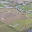
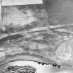
A 29216 |
RCAHMS Aerial Photography |
Oblique aerial view. |
1984 |
Item Level |
|
|
Photographs and Off-line Digital Images |
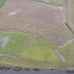
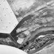
A 29217 |
RCAHMS Aerial Photography |
Oblique aerial view. |
1984 |
Item Level |
|
|
Photographs and Off-line Digital Images |
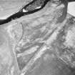
A 29218 |
RCAHMS Aerial Photography |
Oblique aerial view. |
1984 |
Item Level |
|
 |
On-line Digital Images |
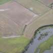
DP 226645 |
Historic Environment Scotland |
General oblique aerial view of the flooding along the River Earn at Masterfield, looking NW. |
17/11/2015 |
Item Level |
|
 |
On-line Digital Images |
DP 226647 |
Historic Environment Scotland |
General oblique aerial view of the flooding along the River Earn at Masterfield, looking WSW. |
17/11/2015 |
Item Level |
|
 |
On-line Digital Images |
DP 226648 |
Historic Environment Scotland |
General oblique aerial view of the flooding along the River Earn at Masterfield, looking SSW. |
17/11/2015 |
Item Level |
|
 |
On-line Digital Images |
SC 1705296 |
RCAHMS Aerial Photography |
Oblique aerial view. |
1984 |
Item Level |
|
 |
On-line Digital Images |
SC 1705297 |
RCAHMS Aerial Photography |
Oblique aerial view. |
1984 |
Item Level |
|
 |
On-line Digital Images |
SC 1705298 |
RCAHMS Aerial Photography |
Oblique aerial view. |
1984 |
Item Level |
|
 |
On-line Digital Images |
SC 2394298 |
Records of the Ordnance Survey, Southampton, Hampshire, England |
Masterfield, NO01NW 47, Ordnance Survey index card, Recto |
c. 1958 |
Item Level |
|


