
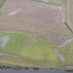
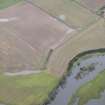
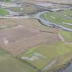
Masterfield


Enclosure(S) (Period Unassigned), Rig And Furrow (Medieval) - (Post Medieval), Ring Ditch(S) (Period Unassigned)
Site Name Masterfield
Classification Enclosure(S) (Period Unassigned), Rig And Furrow (Medieval) - (Post Medieval), Ring Ditch(S) (Period Unassigned)
Canmore ID 26639
Site Number NO01NW 38
NGR NO 01063 17280
NGR Description Centred NO 01063 17280
Datum OSGB36 - NGR
Permalink http://canmore.org.uk/site/26639


- Council Perth And Kinross
- Parish Dunning
- Former Region Tayside
- Former District Perth And Kinross
- Former County Perthshire
NO01NW 38 Centred NO 01063 17280
Scheduled as 'Masterfield, ring-ditches and associated features'.
Information from Historic Scotland, scheduling document dated 28 February 2000.

