
Pricing Change
New pricing for orders of material from this site will come into place shortly. Charges for supply of digital images, digitisation on demand, prints and licensing will be altered.
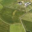
Ronald's Croft


Farmstead (Period Unassigned)
Site Name Ronald's Croft
Classification Farmstead (Period Unassigned)
Alternative Name(s) Hawthornden; Cairnglass Croft
Canmore ID 265757
Site Number NK06SW 162
NGR NK 0426 6238
Datum OSGB36 - NGR
Permalink http://canmore.org.uk/site/265757


- Council Aberdeenshire
- Parish Lonmay
- Former Region Grampian
- Former District Banff And Buchan
- Former County Aberdeenshire
NK06SW 162 0426 6238
(Location cited as NK 0426 6238). Ronald's Croft: site of a now-destroyed farmstead. The 1st edition of the OS map (1867) depicts three rectangular buildings.
NMRS, MS/2059.

