|
Photographs and Off-line Digital Images |
ORD 7/13 |
Copies from a collection of material relating to Inveraray Castle and Estate, Argyll, Scotland |
Photographic copy of part of drawing showing chart of the Orkney Islands. |
1790 |
Item Level |
|
|
Photographs and Off-line Digital Images |
ORD 7/14 |
Copies from a collection of material relating to Inveraray Castle and Estate, Argyll, Scotland |
Photographic copy of part of drawing showing chart of the Orkney Islands. |
1790 |
Item Level |
|
|
Photographs and Off-line Digital Images |
ORD 7/15 |
Copies from a collection of material relating to Inveraray Castle and Estate, Argyll, Scotland |
Photographic copy of part of drawing showing chart of the Orkney Islands. |
1790 |
Item Level |
|
|
Photographs and Off-line Digital Images |
ORD 7/16 |
Copies from a collection of material relating to Inveraray Castle and Estate, Argyll, Scotland |
Photographic copy of part of drawing showing chart of the Orkney Islands. |
1790 |
Item Level |
|
|
Prints and Drawings |
ORD 7/1 |
|
Distribution map of brochs in the Orkney Islands. |
|
Item Level |
|
|
Prints and Drawings |
ORD 7/8 |
|
Ordnance survey map sheet 4, showing S Orkney Islands. |
1910 |
Item Level |
|
|
Prints and Drawings |
ORD 7/9 |
Records of the Royal Commission on the Ancient and Historical Monuments of Scotland (RCAHMS), Edinbu |
Map of the Orkney Islands, showing locations of principal monuments in RCAHMS Inventory. |
1939 |
Item Level |
|
|
Prints and Drawings |
ORD 7/10 |
Records of the Royal Commission on the Ancient and Historical Monuments of Scotland (RCAHMS), Edinbu |
Draft map of the Orkney Islands, showing locations of principal monuments in RCAHMS Inventory. |
1939 |
Item Level |
|
|
Prints and Drawings |
ORD 7/11 |
Records of the Royal Commission on the Ancient and Historical Monuments of Scotland (RCAHMS), Edinbu |
Draft map of the Orkney Islands, showing locations of principal monuments in RCAHMS Inventory. |
1939 |
Item Level |
|
|
Prints and Drawings |
ORD 7/12 |
Records of the Royal Commission on the Ancient and Historical Monuments of Scotland (RCAHMS), Edinbu |
Draft map of the Orkney Islands, showing locations of principal monuments in RCAHMS Inventory. |
1939 |
Item Level |
|
|
Manuscripts |
MS 307/275 |
|
Statistical Account.
Agricultural survey. |
|
Item Level |
|
 |
On-line Digital Images |
DP 068397 |
RCAHMS Aerial Photography Digital |
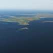
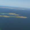
General oblique aerial view looking towards the Holm of Huip and Stronsay beyond, taken from the NE. |
5/8/2009 |
Item Level |
|
 |
On-line Digital Images |
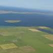
DP 068475 |
RCAHMS Aerial Photography Digital |
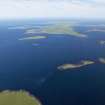
General oblique aerial view of Stronsay across Spurness Sound, taken from the NW. |
5/8/2009 |
Item Level |
|
 |
On-line Digital Images |
DP 068476 |
RCAHMS Aerial Photography Digital |
General oblique aerial view of Stronsay across Spurness Sound, taken from the NW. |
5/8/2009 |
Item Level |
|
 |
On-line Digital Images |
DP 083391 |
RCAHMS Aerial Photography Digital |
Oblique aerial view across the Bay of Holland, Stronsay with Papa Stronsay beyond, taken from the SW. |
6/8/2009 |
Item Level |
|
 |
On-line Digital Images |
DP 083392 |
RCAHMS Aerial Photography Digital |
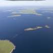
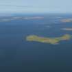
General oblique aerial view of Linga Holm, Stronsay, taken from the SE. |
6/8/2009 |
Item Level |
|
 |
On-line Digital Images |
DP 083393 |
RCAHMS Aerial Photography Digital |
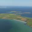
General oblique aerial view of the N of Stronsay with Papa Stronsay beyond, taken from the S. |
6/8/2009 |
Item Level |
|
 |
On-line Digital Images |
DP 083401 |
RCAHMS Aerial Photography Digital |
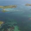
General oblique aerial view looking across Papa Sound towards Papa Stronsay, taken from the W. |
6/8/2009 |
Item Level |
|
 |
On-line Digital Images |
DP 083403 |
RCAHMS Aerial Photography Digital |
General oblique aerial view from the N end of Stronsay looking towards the Holm of Huip and Spurness Sound, taken from the SSE. |
6/8/2009 |
Item Level |
|
 |
On-line Digital Images |
DP 083406 |
RCAHMS Aerial Photography Digital |
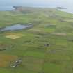
General oblique aerial view looking towards the SW end of Stronsay to Lamb Head with Meikle Water to the left, taken from the NE. |
6/8/2009 |
Item Level |
|
 |
On-line Digital Images |
DP 083409 |
RCAHMS Aerial Photography Digital |
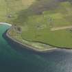
Oblique aerial view centred on Longbigging farmstead with feeder bin stances visible on the shoreline adjacent, taken from the NW. |
6/8/2009 |
Item Level |
|
 |
On-line Digital Images |
DP 083410 |
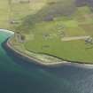
RCAHMS Aerial Photography Digital |
Oblique aerial view centred on Longbigging farmstead with feeder bin stances visible on the shoreline adjacent, taken from the NW. |
6/8/2009 |
Item Level |
|
 |
On-line Digital Images |
DP 143083 |
RCAHMS Aerial Photography Digital |
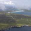
General oblique aerial view of the Bu Wind Farm, Stronsay, looking N. |
18/7/2012 |
Item Level |
|
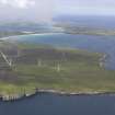 |
On-line Digital Images |
DP 143084 |
RCAHMS Aerial Photography Digital |
General oblique aerial view of the Bu Wind Farm, Stronsay, looking N. |
18/7/2012 |
Item Level |
|


