
Forteviot


Barrow Cemetery (Medieval), Henge(S) (Neolithic) - (Bronze Age)(Possible), Ring Ditch (Period Unassigned), Settlement (Prehistoric), Short Cist (Bronze Age), Timber Circle(S) (Neolithic), Timber Enclosure (Neolithic), Dagger(S) (Period Unassigned), Inorganic Material (Iron)(Period Unassigned), Lithic Implement(S) (Period Unassigned), Organic Material (Period Unassigned), Scabbard (Period Unassigned)
Site Name Forteviot
Classification Barrow Cemetery (Medieval), Henge(S) (Neolithic) - (Bronze Age)(Possible), Ring Ditch (Period Unassigned), Settlement (Prehistoric), Short Cist (Bronze Age), Timber Circle(S) (Neolithic), Timber Enclosure (Neolithic), Dagger(S) (Period Unassigned), Inorganic Material (Iron)(Period Unassigned), Lithic Implement(S) (Period Unassigned), Organic Material (Period Unassigned), Scabbard (Period Unassigned)
Canmore ID 26565
Site Number NO01NE 33
NGR NO 05264 16928
Datum OSGB36 - NGR
Permalink http://canmore.org.uk/site/26565


First 100 images shown. See the Collections panel (below) for a link to all digital images.
- Council Perth And Kinross
- Parish Forteviot
- Former Region Tayside
- Former District Perth And Kinross
- Former County Perthshire
NO01NE 33 0527 1692
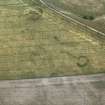
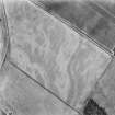
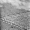
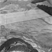
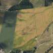
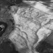
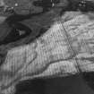
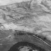
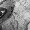
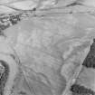
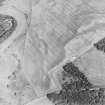
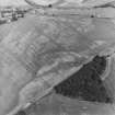
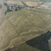
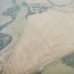
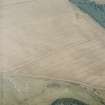
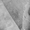
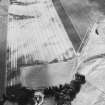
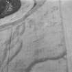
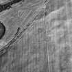
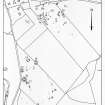
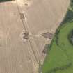
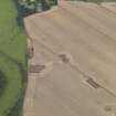
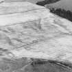
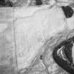
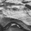
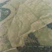
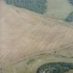
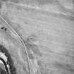
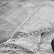
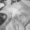
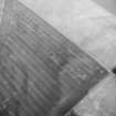
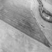
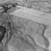
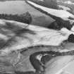
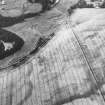
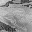
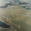
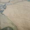
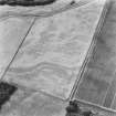
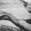
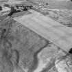
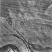
A penannular ditch is enclosed by a ring of post-pits about 22 of which can be identified, defining an area about 44m in diameter, immediately to the south a small penannular ditch forms a ring enclosure and further to the SE a ring 4 to 5m in diameter may be a hut.
J K St Joseph 1976; 1978.
This ring-ditch is plotted as a Class I henge on a distribution map of henge monuments, ring-cairns, pit-circles and recumbent stone circles covering central and eastern Scotland (RCAHMS 1994, 39, fig. A).
Information from RCAHMS (ARG) 17 October 1997.
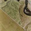
Aerial Photographic Transcription (16 May 1991 - 11 June 1991)
An aerial transcription was produced from oblique aerial photographs. Information from Historic Environment Scotland (BM) 31 March 2017.
Project (April 2008 - 24 August 2008)
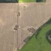
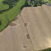
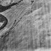
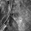
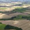
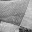
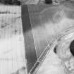
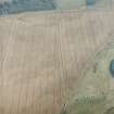
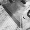
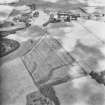
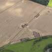
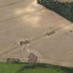
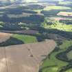
NO 0526 1692 A cropmark complex was identified during aerial reconnaissance across three fields immediately to the S of Forteviot in the 1970s. It consists of a probable Neolithic palisaded enclosure, a number of possible henge monuments, later prehistoric settlement and an early medieval barrow and long grave cemetery.
The avenue of the palisaded enclosure and a small component of the cemetery were excavated in 2007 (DES
2007, 157–8). The focus of fieldwork in 2008 was a putative henge monument and timber circle within the palisaded enclosure. A geophysical survey was carried out over the henge cropmark in April 2008, although the results of this survey (resistivity and magnetometry) revealed little more than is visible as cropmarks.
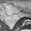
Excavations carried out 4–24 August 2008 focussed on opening a trench over the eastern half of the henge, exposing about one third of the monument. The trench was machine opened, but the quantity of stone uncovered led to much of the trench being excavated by hand. A complicated sequence of events that appear to have both pre- and post-dated the henge was recorded, with at least five distinctive elements or phases of activity identified.
Pre-henge activity – A large but shallow oval pit was dug and a large megalithic sandstone block, measuring about 2.1 x 2 x 0.5m was placed in it. The pit was subsequently filled with rounded and angular stones, perhaps cairn material. This pit feature was subsequently enclosed within the henge.
Outside the henge, aerial photography indicated the presence of a timber circle c40m in diameter surrounding
the henge. Two postholes were excavated that revealed little more about this monument, but on the basis of other sites where henges and timber circles occur together, it seems more likely that the timber circle was the earlier of the two. In turn, the ‘megalithic’ element of this monument may well be the earliest element of the site although its character is as yet unclear.
The henge itself is identifiable from the air by two or three ditched features (35m N/S by 30m E/W) that enclose a central area approximately 22m N/S by 21m E/W. The henge has at least one entrance. Two sections were excavated through the ditch, one on the eastern side of the monument, the other across a ditch terminal. The ditch was shown to be substantial, with a maximum depth of 2.8m and a width of 11m, noticeably steeper on the internal side. A series of fills were identified inside the henge, mostly silts, and charcoal deposits and six sherds of the same Beaker were associated with the lower fills in the terminal section. About 1m from the top of the ditch, a deposit of possibly burnt turves or soil was found in the interior side of the ditch, and this was followed by a capping of clay across the whole ditch. No traces of a bank were found, nor any internal features associated with the henge.
Post-henge – The monument seems to have undergone substantial re-working, perhaps in the medieval period.
The upper fill of the henge ditch, immediately above the clay level, consisted of large boulders and angular rubble, mostly basalt possibly quarried from a nearby quarry on the Dronachy ridge (NO01NE 106). The rubble and boulder fill seems to have been levelled out with cobbling, and traces of a compact ash skim across these cobbles survived in a very few locations. Around this time, or perhaps a little later, a large pit was dug in the central area of the henge. This shows as a cropmark ‘blob’ measuring approximately 12 x 6m, aligned NE/SW. Sections through this indicated it was a deep feature, at least 2.5m in depth, with a uniform silty fill that included sherds of Roman amphora and medieval White Gritty ware.
Analysis of environmental samples and a dating programme is ongoing, but at this stage we can speculate that
this timber circle and henge monument enclosed an earlier and unusual megalithic monument, and was subsequently radically altered, perhaps by high-status medieval activity. This sequence will be further examined in the 2009 season.
A second trench was opened in the central area of the palisaded enclosure. This trench, 10 x 20m, was located to examine the pitted features appearing as cropmarks. Within the trench a few insubstantial features and a possible treethrow were half-sectioned. The only feature of note, which was visible as a cropmark, was a sub-oval pit filled with clay and carbonised material which was subsequently cut by a field drain. The nature of this feature is as yet unclear as it rapidly flooded with the slightest rainfall and we were unable to excavate it fully. Environmental samples were taken and will be examined as part of our post-excavation programme.
www.gla.ac.uk/archaeology/research/projects/SERF
Archive: RCAHMS
Funder: British Academy, Historic Scotland, Department of Archaeology University of Glasgow and Society of Antiquaries of Scotland
Kenneth Brophy and Gordon Noble (Department of Archaeology University of Glasgow / Department of Archaeology, University of Aberdeen, 2008
Earth Resistance Survey (April 2008 - 24 August 2008)
NO 0526 1692 Resisitivity survey.
www.gla.ac.uk/archaeology/research/projects/SERF
Archive: RCAHMS
Funder: British Academy, Historic Scotland, Department of Archaeology University of Glasgow and Society of Antiquaries of Scotland
Kenneth Brophy and Gordon Noble (Department of Archaeology University of Glasgow / Department of Archaeology, University of Aberdeen, 2008
Magnetometry (April 2008 - 24 August 2008)
NO 0526 1692 Magnetometry survey.
www.gla.ac.uk/archaeology/research/projects/SERF
Archive: RCAHMS
Funder: British Academy, Historic Scotland, Department of Archaeology University of Glasgow and Society of Antiquaries of Scotland
Kenneth Brophy and Gordon Noble (Department of Archaeology University of Glasgow / Department of Archaeology, University of Aberdeen, 2008
Excavation (2009)
NO 0526 1692 A cropmark complex was identified during aerial reconnaissance across three fields immediately to the S of Forteviot in the 1970s. It consists of a probable Neolithic palisaded enclosure, a number of possible henge monuments, later prehistoric settlement and an early medieval barrow and long grave cemetery.
The avenue of the palisaded enclosure and a small component of the cemetery were excavated in 2007 (DES
2007, 157–8). In 2008 efforts turned to a henge monument within the palisaded enclosure and we undertook geophysics and excavation in the NE quadrant of the henge (DES 2008, 145). Our 2009 trench was L-shaped and focused on the western and southern elements of the henge, as well as a range of features around and to the S of the henge ditch. These were sampled, including the half-sectioning of three postholes that formed part of a timber circle that surrounds the henge.
During the 2008 season a large pit within the henge was excavated and found to contain a huge squarish sandstone block, c2.4m wide and 0.5m thick, and estimated to weigh 4–5 tonnes. One of the key aims of the 2009 season was to lift this block. This was done during the first week of the excavation using a crane, and the slab was found to have been a capstone covering a Bronze Age short cist, which was in remarkably good condition. The cist contained no bones, but a range of organics, metalwork and lithics were found. These included two daggers, of a kind associated with the centuries around 2000 BC, as well as a scabbard, plant
remains, a lump of iron ore and worked lithics. Analysis of this material is ongoing (funded by Historic Scotland). The capstone of the cist had on its underside an enigmatic rockart motif, without close parallel in the British Isles. Excavation of the henge monument also continued. The henge ditch was found to be of a similar scale to sections investigated in 2008, around 2m in depth and up to 10m wide. No evidence was found for a re-cut and little for a bank; it was established that the henge ditch’s interior edge was cut by the pit for the cist. The henge ditch seems to have filled through a combination of natural silting and deliberate deposits of burnt material. There was also evidence for episodes of standing water in the ditch. In the western half of the henge, a complex series of scoops, hollows and silt deposits related to a cremation cemetery, with a number of discrete cremation deposits. These may have been placed in the ground in organic containers (no longer surviving), and at least one was associated with later prehistoric potsherds. A possible broken standing stone was also located in this area. Work will resume here in 2010.
Excavation of a huge pit in the northern half of the henge also continued; as with the 2008 sondage, the silt fills of this pit contained medieval pot sherds, but bone was also found in 2009. Analysis of the environmental samples taken from this, and other features, is ongoing.
Archive: University of Glasgow and RCAHMS (intended)
Funder: Historic Scotland, University of Glasgow and University of Aberdeen
Kenneth Brophy and Gordon Noble – SERF Project, Departments of Archaeology, Universities of Glasgow and Aberdeen
Note (11 April 2014)
Excavation revealed that this enclosure was defined by large timber posts and not by the continuous bedding trench of a palisade. As such the classification has been changed from palisaded enclosure to timber enclosure. Excavation has also shown that two circles of pits within the enclosure, first recorded as cropmarks on aerial photographs, were also defined by timber posts and so represent the remains of timber circles.
Information from RCAHMS (KMM) 11 April 2014
Geophysical Survey (2015)
A programme of geophysical survey was undertaken in 2015 across a number of known archaeological sites in Perth and Kinross:
NO 02182 15001 (Canmore ID: 26662, SMR: 3675) Dunning – Roman temporary camp
NO 01900 15900 (Canmore ID: 26621, SMR: 9158) Leadketty – Enclosures, causewayed enclosure, ring ditches, square barrow and pits
NO 03940 17530 (Canmore ID: 26608) Forteviot – Roman temporary camp
NO 05353 16830 (Canmore ID: 26565) Forteviot – Henges, enclosures, square barrows and pits
NO 02600 15700 (Canmore ID: 84940, SMR: 8918) – Pit alignment.
Archive and report: National Record of the Historic Environment (NRHE)
Funder: Historic Scotland
Website: www.glasgow.ac.uk/serf
Tessa Poller and Dene Wright – University of Glasgow
(Source: DES, Volume 16)

