
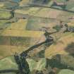
Forteviot


Enclosure (Period Unassigned), Henge (Neolithic) - (Bronze Age)
Site Name Forteviot
Classification Enclosure (Period Unassigned), Henge (Neolithic) - (Bronze Age)
Canmore ID 26564
Site Number NO01NE 32
NGR NO 05248 16991
Datum OSGB36 - NGR
Permalink http://canmore.org.uk/site/26564


First 100 images shown. See the Collections panel (below) for a link to all digital images.
- Council Perth And Kinross
- Parish Forteviot
- Former Region Tayside
- Former District Perth And Kinross
- Former County Perthshire
NO01NE 32 05248 16991
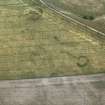
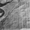
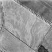
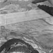
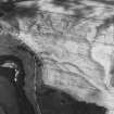
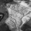
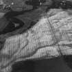
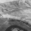
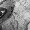
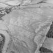
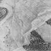
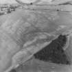
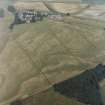
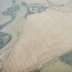
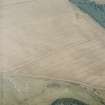
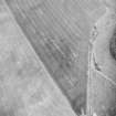
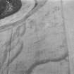
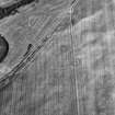
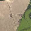
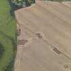
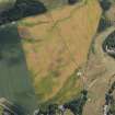
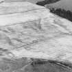
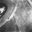
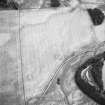
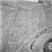
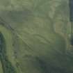
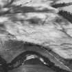
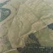
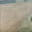
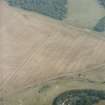
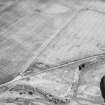
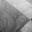
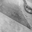
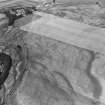
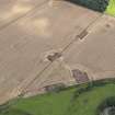
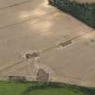
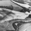
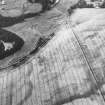
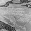
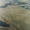
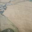
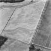
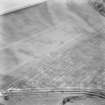
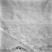
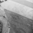
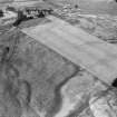
Two arcs of a ditch form a circle, 19m internal diameter, with two entrances. There is a narrow inner ditch.
J K St Joseph 1976; 1978.
This enclosure is plotted as a Class II henge on a distribution map of henge monuments, ring-cairns, pit-circles and recumbent stone circles covering central and eastern Scotland (RCAHMS 1994, 39, fig. A).
Information from RCAHMS (ARG) 17 October 1997.
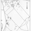
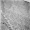
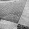
Aerial Photographic Transcription (16 May 1991 - 11 June 1991)
An aerial transcription was produced from oblique aerial photographs. Information from Historic Environment Scotland (BM) 31 March 2017.
Project (May 2010 - August 2010)
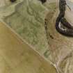
A series of geophysical surveys were carried out over four targeted areas in the main prehistoric ritual complex at Forteviot in May–August 2010. The surveys aimed to confirm the survival of archaeological features identified by aerial photography and identify any other areas of archaeological interest.
NO 0524 1699 Double ditch enclosure A multi-technique geophysical survey was carried out over this feature to assess the capabilities of four near-surface geophysical techniques (earth resistance, gradiometry, ground penetrating radar and EM38) as part of a PhD project. The two ditches of the enclosure were detected by the gradiometer survey. The earth resistance survey detected only the outer ditch of the enclosure and a central pit. The EM38 survey detected the structure after the stripping of the topsoil. The partial GPR survey successfully detected the targeted ditch.
NO 0534 1705 Henge The gradiometer survey carried out in this area clearly detected the wide ditches associated with this structure as well as the central pit.
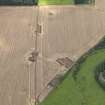
NO 0547 1746 Square barrows The gradiometer survey carried out in this area identified the central grave of the W barrow but it did not detect any ditches.
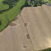
NO 0543 1695 Palisaded enclosure A gradiometry survey carried out across the NE corner of the palisaded enclosure suggested the enclosure may have had an accompanying linear ditch in places, and that several of the postholes were burnt in situ. A notable large dipolar anomaly was recorded within the interior of the enclosure.
Archive: RCAHMS (intended)
Funder: NERC, Historic Scotland and University of Glasgow
University of Glasgow, 2010
Magnetometry (May 2010 - August 2010)
NO 0524 1699 Double ditch enclosure. A multi-technique geophysical survey was carried out over this feature to assess the capabilities of four near-surface geophysical techniques (earth resistance, gradiometry, ground penetrating radar and EM38) as part of a PhD project. The two ditches of the enclosure were detected by the gradiometer survey.
NO 0534 1705 Henge. The gradiometer survey carried out in this area clearly detected the wide ditches associated with this structure as well as the central pit.
NO 0547 1746 Square barrows. The gradiometer survey carried out in this area identified the central grave of the W barrow but it did not detect any ditches.
NO 0543 1695 Palisaded enclosure. A gradiometry survey carried out across the NE corner of the palisaded enclosure suggested the enclosure may have had an accompanying linear ditch in places, and that several of the postholes were burnt in situ. A notable large dipolar anomaly was recorded within the interior of the enclosure.
Archive: RCAHMS (intended)
Funder: NERC, Historic Scotland and University of Glasgow
University of Glasgow, 2010
Magnetic Susceptibility (May 2010 - August 2010)
NO 0524 1699 Double ditch enclosure A multi-technique geophysical survey was carried out over this feature to assess the capabilities of four near-surface geophysical techniques (earth resistance, gradiometry, ground penetrating radar and EM38) as part of a PhD project. The EM38 survey detected the structure after the stripping of the topsoil.
Archive: RCAHMS (intended)
Funder: NERC, Historic Scotland and University of Glasgow
University of Glasgow, 2010
Ground Penetrating Radar (May 2010 - August 2010)
NO 0524 1699 Double ditch enclosure A multi-technique geophysical survey was carried out over this feature to assess the capabilities of four near-surface geophysical techniques (earth resistance, gradiometry, ground penetrating radar and EM38) as part of a PhD project. The partial GPR survey successfully detected the targeted ditch.
Archive: RCAHMS (intended)
Funder: NERC, Historic Scotland and University of Glasgow
University of Glasgow, 2010
Earth Resistance Survey (May 2010 - August 2010)
NO 0524 1699 Double ditch enclosure A multi-technique geophysical survey was carried out over this feature to assess the capabilities of four near-surface geophysical techniques (earth resistance, gradiometry, ground penetrating radar and EM38) as part of a PhD project. The earth resistance survey detected only the outer ditch of the enclosure and a central pit.
Archive: RCAHMS (intended)
Funder: NERC, Historic Scotland and University of Glasgow
University of Glasgow, 2010

