
Greenock, Port Glasgow Road, Graving Dock, Repair Quay


Quay (19th Century) - (20th Century)
Site Name Greenock, Port Glasgow Road, Graving Dock, Repair Quay
Classification Quay (19th Century) - (20th Century)
Alternative Name(s) Inchgreen Dockyard; Firth Of Clyde Dry Dock Co.; Bogston; Ladyburn; Greenock Harbour
Canmore ID 264625
Site Number NS37NW 17.01
NGR NS 30340 75460
NGR Description NS 30340 75460 to 30690 75280
Datum OSGB36 - NGR
Permalink http://canmore.org.uk/site/264625


- Council Inverclyde
- Parish Greenock
- Former Region Strathclyde
- Former District Inverclyde
- Former County Renfrewshire
NS37NW 17.01 30340 75460 to 30690 75280
For summary account, see NS37NW 17.00.
Note (6 June 2017)
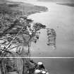
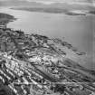
The East Jetty was constructed in the late 19th century as part of a scheme to enable Greenock docks and harbours to compete with those elsewhere on the Clyde but particularly Glasgow. The new development saw the former natural foreshore, at that time in use for the wet storage of timber (NS37NW 82), filled in and the construction up to 220m off shore (and up to 50m beyond the low water mark) of a 530m long battered stone wall. The 2nd edition of the OS 6-inch (Renfrewshire 1896, Sheets 002.06 and 002.07) shows that ground to the SE was also partly reclaimed. Since then, the battered wall has been replaced with one with a vertical face that extends well beyond the SE end of the original work.
Information from HES, Survey and Recording (AKK) 2 April 2017.

