
Pricing Change
New pricing for orders of material from this site will come into place shortly. Charges for supply of digital images, digitisation on demand, prints and licensing will be altered.
Castle Knowe


Slit Trench(S) (First World War), Slit Trench (20th Century), Trench(S) (First World War)
Site Name Castle Knowe
Classification Slit Trench(S) (First World War), Slit Trench (20th Century), Trench(S) (First World War)
Canmore ID 263926
Site Number NT26SW 117
NGR NT 22937 64109
Datum OSGB36 - NGR
Permalink http://canmore.org.uk/site/263926


- Council Midlothian
- Parish Glencorse
- Former Region Lothian
- Former District Midlothian
- Former County Midlothian
NT26SW 117 22937 64109
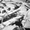
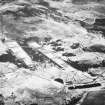
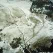
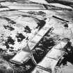
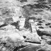
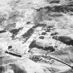
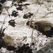
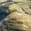
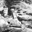
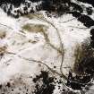
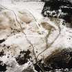
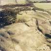
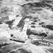
There are a series of practice trenches on Castle Knowe, which are probably of World War I date.
Information from RCAHMS (DCC) 2 September 2004.
A system of practice trenches immediately NW of Castle Knowe probably dates from around the time of the First World War and conform to front-line design (British Trench Warfare 1917-1918, published by General Staff at the British War Office). Enclosing a roughly square area up to 120m across, the trenches are now visible as hollows little more than 1m in breadth and 0.2m in depth. The trenches forming the NE and SW sides of the area form an 'equal trench and traverse' pattern, with further, short runs of trench branching off. These may be interpreted as practice front-line and support trenches. The trenches forming the NW and SE sides of the square, together with a third which runs across the middle of the area from NE to SW, are zigzag 'tenaille' on plan, and they too have short branches springing off them. These trenches are practice communication trenches.
Other features within and around the practice trenches include a number of narrow slit-trenches, which generally measure between 1m and 2.5m in length by no more than 0.2m in depth. Some of these slit-trenches appear to be directly associated with the practice trench-system, but others represent the western part of a distribution of similar features to the NE (see NT26SW 138). Within the N part of the area there is a line, some 45m in length from E to W, of eight roughly square areas measuring up to 1.7m across, from which the turf has been removed. This line straddles one of the practice trenches and is therefore probably later in date.
Visited by RCAHMS (JRS) 7 June 2005.
Project (March 2013 - September 2013)
A project to characterise the quantity and quality of the Scottish resource of known surviving remains of the First World War. Carried out in partnership between Historic Scotland and RCAHMS.

