
Pricing Change
New pricing for orders of material from this site will come into place shortly. Charges for supply of digital images, digitisation on demand, prints and licensing will be altered.
Upcoming Maintenance
Please be advised that this website will undergo scheduled maintenance on the following dates:
Thursday, 30 January: 11:00 AM - 3:00 PM
During these times, some functionality such as image purchasing may be temporarily unavailable. We apologise for any inconvenience this may cause.
Pitnacree


Barrow (Prehistoric), Unidentified Pottery (Neolithic)
Site Name Pitnacree
Classification Barrow (Prehistoric), Unidentified Pottery (Neolithic)
Alternative Name(s) Pitnacree House Policies
Canmore ID 26384
Site Number NN95SW 6
NGR NN 9287 5337
Datum OSGB36 - NGR
Permalink http://canmore.org.uk/site/26384


- Council Perth And Kinross
- Parish Logierait
- Former Region Tayside
- Former District Perth And Kinross
- Former County Perthshire
NN95SW 6 9287 5337
(NN 9287 5337) Standing Stone (NAT)
OS 6" map, Perthshire, 2nd ed., (1902)
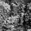
A Neolithic round barrow excavated in 1964 at Pitnacree. A mound 90' in maximum diameter and 9' high, the only visible features being a small standing stone projecting 3' from the centre, and a large recumbent slab 14' SW of the standing stone.
The barrow was found to have been built of turf and stone over a penannular ring-cairn and was bounded by a dry-stone kerb. Inside the cairn, a dry-stone (blocked) entrance led into a stone rectangular enclosure, built over four cremations carbon dated to c. 2860 BC (information from lecture notes from a paper given by D D A Simpson to Soc Antiq Scot, 11 October 1965) and two ramped stone or post holes. Neolithic pottery was recovered from the old land surface beneath the barrow and a cremation, carbon dated to c. 2270 BC (information from lecture notes from a paper given by D D A Simpson to Soc Antiq Scot, 11 October 1965) from under the standing stone on top of the mound.
J M Coles and D D A Simpson 1964; J M Coles and D D A Simpson 1965.
Finds from the excavation were donated to the NMAS by C B Sheriff, Ballinluig.
NMAS 1967.
This barrow still supports several large conifers. The perimeter has been confused by ploughing and the mound now measures 27.5m N-S by 23.5m and is 2.0m high. The standing stone survives in the centre, but no other constructional stones are visible.
Surveyed at 1:2500.
Visited by OS (A A) 18 March 1975.

