
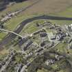
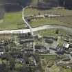
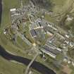
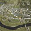
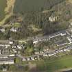
Walkerburn, Galashiels Road, Tweedvale Mills, East Mill Block


Woollen Mill (19th Century)
Site Name Walkerburn, Galashiels Road, Tweedvale Mills, East Mill Block
Classification Woollen Mill (19th Century)
Alternative Name(s) Ballantyne's Mill; Tweeddale Mills
Canmore ID 263833
Site Number NT33NE 24.02
NGR NT 36108 37033
Datum OSGB36 - NGR
Permalink http://canmore.org.uk/site/263833


- Council Scottish Borders, The
- Parish Innerleithen
- Former Region Borders
- Former District Tweeddale
- Former County Peebles-shire
NT33NE 24.02 36108 37033

