 |
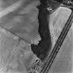
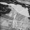
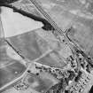
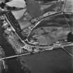
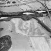
On-line Digital Images |
SC 1704329 |
RCAHMS Aerial Photography |
Logierait, oblique aerial view, taken from the SW, centred on the cropmarks of a fort. |
17/8/1995 |
Item Level |
|
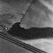 |
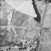
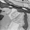
On-line Digital Images |
SC 1704330 |
RCAHMS Aerial Photography |
Logierait, oblique aerial view, taken from the SE, centred on the cropmarks of a fort. |
17/8/1995 |
Item Level |
|
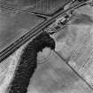 |
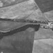
On-line Digital Images |
SC 1704331 |
RCAHMS Aerial Photography |
Logierait, oblique aerial view, taken from the NNE, centred on the cropmarks of a fort. |
17/8/1995 |
Item Level |
|
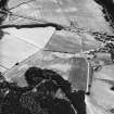 |
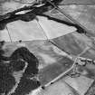
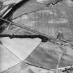
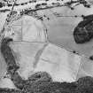
On-line Digital Images |
SC 1704342 |
RCAHMS Aerial Photography |
Logierait, oblique aerial view taken from the NW, centred on the cropmarks of a souterrain, roundhouses, pits and a fort. A possible enclosure is also visible in the top left hand corner. There are also numerous linear cropmarks showing in the photograph. |
16/7/1996 |
Item Level |
|
 |
On-line Digital Images |
SC 1704343 |
RCAHMS Aerial Photography |
Logierait, oblique aerial view taken from the W, centred on the cropmarks of a souterrain, roundhouses, pits and a fort. A possible enclosure is also visible in the top centre of the photograph. There are also numerous linear cropmarks showing in the photograph. |
16/7/1996 |
Item Level |
|
 |
On-line Digital Images |
SC 1704344 |
RCAHMS Aerial Photography |
Logierait, oblique aerial view taken from the SW, centred on the cropmarks of a souterrain, roundhouses, pits and a fort. There are also numerous linear cropmarks showing in the photograph. |
16/7/1996 |
Item Level |
|
 |
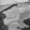
On-line Digital Images |
SC 1704345 |
RCAHMS Aerial Photography |
Logierait, oblique aerial view taken from the NE, centred on the cropmarks of a souterrain, roundhouses, pits and a fort. |
16/7/1996 |
Item Level |
|
 |
On-line Digital Images |
SC 1704346 |
RCAHMS Aerial Photography |
Logierait, oblique aerial view taken from the N, centred on the cropmarks of a souterrain, roundhouses, pits and a fort. |
16/7/1996 |
Item Level |
|
 |
On-line Digital Images |
SC 1704347 |
RCAHMS Aerial Photography |
Logierait, oblique aerial view taken from the NW, centred on the cropmarks of a souterrain, roundhouses, pits and a fort. A possible enclosure is also visible in the left hand centre of the photograph. |
16/7/1996 |
Item Level |
|
 |
On-line Digital Images |
SC 1704348 |
RCAHMS Aerial Photography |
Logierait, oblique aerial view taken from the W, centred on the cropmarks of a souterrain, roundhouses, pits and a fort. A possible enclosure is also visible in the top left hand corner of the photograph. |
16/7/1996 |
Item Level |
|
 |
On-line Digital Images |
SC 1704349 |
RCAHMS Aerial Photography |
Logierait, oblique aerial view taken from the SW, centred on the cropmarks of a souterrain, roundhouses, pits and a fort. A possible enclosure is also visible in the top right hand corner of the photograph. There are also numerous linear cropmarks showing in the photograph. |
16/7/1996 |
Item Level |
|
 |
On-line Digital Images |
SC 1704350 |
RCAHMS Aerial Photography |
Oblique aerial view. |
1992 |
Item Level |
|
 |
On-line Digital Images |
SC 1704351 |
RCAHMS Aerial Photography |
Oblique aerial view. |
1992 |
Item Level |
|
 |
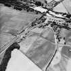
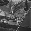
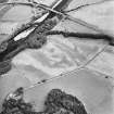
On-line Digital Images |
SC 1704355 |
RCAHMS Aerial Photography |
Oblique aerial view centred on the site of the castle, the cropmarks of the fort, rig and the enclosures taken from the E. |
31/7/2001 |
Item Level |
|
 |
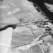
On-line Digital Images |
SC 1704356 |
RCAHMS Aerial Photography |
Oblique aerial view centred on the site of the castle, the cropmarks of the fort, rig and the enclosures taken from the NNE. |
31/7/2001 |
Item Level |
|
 |
On-line Digital Images |
SC 1704357 |
RCAHMS Aerial Photography |
Oblique aerial view centred on the site of the castle, the cropmarks of the fort, rig and the enclosures taken from the NW. |
31/7/2001 |
Item Level |
|
 |
On-line Digital Images |
SC 1704358 |
RCAHMS Aerial Photography |
Oblique aerial view centred on the site of the castle, the cropmarks of the fort, rig and the enclosures taken from the W. |
31/7/2001 |
Item Level |
|
 |
On-line Digital Images |
SC 1704359 |
RCAHMS Aerial Photography |
Oblique aerial view centred on the site of the castle, the cropmarks of the fort, rig and the enclosures taken from the SW. |
31/7/2001 |
Item Level |
|
 |
On-line Digital Images |
SC 1704371 |
RCAHMS Aerial Photography |
Oblique aerial view. |
1978 |
Item Level |
|
 |
On-line Digital Images |
SC 1704372 |
RCAHMS Aerial Photography |
Oblique aerial view. |
1978 |
Item Level |
|
 |
On-line Digital Images |
SC 1704373 |
RCAHMS Aerial Photography |
Oblique aerial view. |
1978 |
Item Level |
|
|
Photographs and Off-line Digital Images |
SC 1925448 |
Cambridge University Collection for Aerial Photography |
|
1952 |
Item Level |
|
 |
On-line Digital Images |
SC 2393640 |
Records of the Ordnance Survey, Southampton, Hampshire, England |
Logierait, NN95SE 32, Ordnance Survey index card, Recto |
1958 |
Item Level |
|
 |
On-line Digital Images |
SC 2393641 |
Records of the Ordnance Survey, Southampton, Hampshire, England |
Logierait, NN95SE 32, Ordnance Survey index card, page number 1, Recto |
1958 |
Item Level |
|


