
Logierait


Fort (Period Unassigned)
Site Name Logierait
Classification Fort (Period Unassigned)
Canmore ID 26338
Site Number NN95SE 32
NGR NN 97241 52018
Datum OSGB36 - NGR
Permalink http://canmore.org.uk/site/26338


- Council Perth And Kinross
- Parish Logierait
- Former Region Tayside
- Former District Perth And Kinross
- Former County Perthshire
NN95SE 32 9722 5201.
House; Palisade
(Undated) information in NMRS.
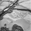
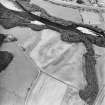
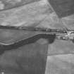
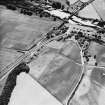
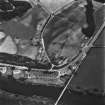
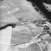
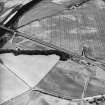
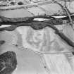
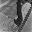
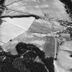
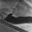
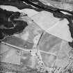
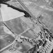
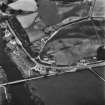
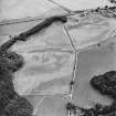
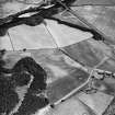
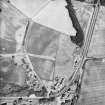
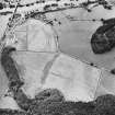
The cropmarks of a double ditched fort have been revealed by aerial photography on a promontory overlooking the Rivers Tay and Tummel, 50m ENE of Claisandear farmsteading. It measures at least 50m by 28m within the ditches. Visible internally are at least three palisade lines and a ring-ditch (probably a round-house) approximately 10m in diameter. The exterior ditches intersect one small ring-ditch, and a further arc of ditch.
Cropmarks including those of a possible souterrain and round-houses, and pits, have been recorded 50m to the N (NN95SE 29).
Information from RCAHMS (KB) 19 August 1999.
Aerial Photographic Transcription (1 May 2012)
Note (6 January 2015 - 18 May 2016)
Cropmarks have revealed the ditches of a fort cutting off a shallow promontory forming part of the escarpment dropping down to the public road crossing the haughland at the confluence of the River Tummel with the Tay. The defences comprise twin ditches about 4m in breadth and set 6m apart, which are drawn in an arc across the northern approaches to the promontory and block access from the NE and NW. The interior measures about 60m from ENE to WSW immediately to the rear of the defences by a maximum of 30m transversely (0.12ha) and is featureless apart from traces of two possible palisade trenches set concentrically within the inner ditch.
Information from An Atlas of Hillforts of Great Britain and Ireland – 18 May 2016. Atlas of Hillforts SC2665

