
Scheduled Maintenance
Please be advised that this website will undergo scheduled maintenance on the following dates: •
Tuesday 12th November from 11:00-15:00 & Thursday 14th November from 11:00-15:00
During these times, some services may be temporarily unavailable. We apologise for any inconvenience this may cause.
Rath Of Logierait


Castle (Medieval)
Site Name Rath Of Logierait
Classification Castle (Medieval)
Alternative Name(s) Tom Na Croiche; Gallows Knoll; Rath Of Logie Rait
Canmore ID 26324
Site Number NN95SE 2
NGR NN 9740 5227
Datum OSGB36 - NGR
Permalink http://canmore.org.uk/site/26324


- Council Perth And Kinross
- Parish Logierait
- Former Region Tayside
- Former District Perth And Kinross
- Former County Perthshire
NN95SE 2 9740 5227.
(NN 9740 5227) Castle (NR) (Site of)
OS 6" map, Perthshire, 2nd ed., (1900)
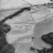
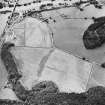
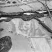
The Rath of Logierait, the remains of a castle (probable 14th century) the favourite resort of several kings of Scotland, notably Robert II. The site of its walls is now overgrown and only one or two fragments of old masonry are to be seen. Stewart (information from M E C Stewart to OS, undated) points out that the ditched enceinte may be older than the enclosed ruins. (c/f ditched homesteads at Fortingall and Strathtay). After 'The Rath' became ruinous (over 300 years ago) it became the Gallows Knoll (Cnoc-na-croiche) of the Regality Court of Logierait. Now the site of a large "Celtic" cross erected to the memory of the 6th Duke of Atholl in 1864.
Although Dixon (1925) infers that Gallows Knoll is on the actual site of the Castle, Stewart sites it to the SW of the monument - at NN 9735 5224.
J Dixon 1925.
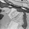
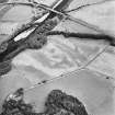
The overgrown remains of this castle are situated on the edge of a terrace overlooking the Tummel valley. The site, which measures 56.0m N-S by 36.0m, is enclosed on the N, S, and W by a ditch up to 18.0m wide and 5.0m deep, while on the E the ground falls away to the River Tummel. There are no structural remains but there are two large pieces of displaced mortared masonry, one of which now lies at the bottom of the ditch. Access to the interior is gained by causeways on the N and S. Although it is not possible to establish a precise date for this site, it has not been formed from a ditched homestead as suggested by Mrs Stewart. There is nothing on the ground to the SW of the monument and nothing to confirm the site of the Gallows Knoll.
Revised at 1:2500.
Visited by OS (B S) 21 January 1975.

