
Broadbrae


Ring Ditch(S) (Period Unassigned)
Site Name Broadbrae
Classification Ring Ditch(S) (Period Unassigned)
Canmore ID 262685
Site Number NH54NW 150
NGR NH 5407 4988
Datum OSGB36 - NGR
Permalink http://canmore.org.uk/site/262685


- Council Highland
- Parish Killearnan
- Former Region Highland
- Former District Ross And Cromarty
- Former County Ross And Cromarty
NH54NW 150 5407 4988
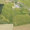
Two ring-ditches have been recorded as cropmarks on oblique aerial photography (RCAHMSAP 2000) lying on level ground about 250m SE of Broadbrae. The smaller of the two measures about 4m in diameter within a narrow ditch. The second lies about 70m to the SW and measures about 12m in diameter within a ditch about 2m wide.
Information from RCAHMS (KMM) 15 July 2004

