|
Photographs and Off-line Digital Images |
D 74288 |
RCAHMS Aerial Photography |
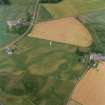
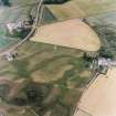
Oblique aerial view centred on the cropmarks of the possible pit-defined enclosure, pits, linear cropmarks and promontory fort with church, mausoleum and cemetery adjacent, taken from the SSW. |
17/7/2000 |
Item Level |
|
|
Photographs and Off-line Digital Images |
D 74290 |
RCAHMS Aerial Photography |
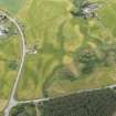
Oblique aerial view centred on the cropmarks of the possible pit-defined enclosure, pits, linear cropmarks and promontory fort with church, mausoleum and cemetery adjacent, taken from the SW. |
17/7/2000 |
Item Level |
|
|
Photographs and Off-line Digital Images |
D 74291 |
RCAHMS Aerial Photography |
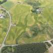
Oblique aerial view centred on the cropmarks of the possible pit-defined enclosure, pits, linear cropmarks and promontory fort with church, mausoleum and cemetery adjacent, taken from the W. |
17/7/2000 |
Item Level |
|
|
Photographs and Off-line Digital Images |
D 74293 |
RCAHMS Aerial Photography |
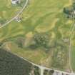
Oblique aerial view centred on the cropmarks of the possible pit-defined enclosure, pits, linear cropmarks and promontory fort with church, mausoleum and cemetery adjacent, taken from the WNW. |
17/7/2000 |
Item Level |
|
|
Photographs and Off-line Digital Images |
D 74294 |
RCAHMS Aerial Photography |
Oblique aerial view centred on the cropmarks of the possible pit-defined enclosure, pits, linear cropmarks and promontory fort with church, mausoleum and cemetery adjacent, taken from the NW. |
17/7/2000 |
Item Level |
|
|
Photographs and Off-line Digital Images |
D 74295 |
RCAHMS Aerial Photography |
Oblique aerial view centred on the cropmarks of the possible pit-defined enclosure, pits, linear cropmarks and promontory fort with church, mausoleum and cemetery adjacent, taken from the NW. |
17/7/2000 |
Item Level |
|
|
Photographs and Off-line Digital Images |
E 98536 CS |
RCAHMS Aerial Photography |
Oblique aerial view centred on the cropmarks of the possible pit-defined enclosure, pits, linear cropmarks and promontory fort with church, mausoleum and cemetery adjacent, taken from the SW. |
17/7/2000 |
Item Level |
|
|
Photographs and Off-line Digital Images |
E 98537 CS |
RCAHMS Aerial Photography |
Oblique aerial view centred on the cropmarks of the possible pit-defined enclosure, pits, linear cropmarks and promontory fort with church, mausoleum and cemetery adjacent, taken from the SW. |
17/7/2000 |
Item Level |
|
|
Photographs and Off-line Digital Images |
D 69485 CN |
RCAHMS Aerial Photography |
Oblique aerial view centred on the cropmarks of the possible pit-defined enclosure, pits, linear cropmarks and promontory fort with church, mausoleum and cemetery adjacent, taken from the WSW. |
17/7/2000 |
Item Level |
|
|
Photographs and Off-line Digital Images |
D 69487 CN |
RCAHMS Aerial Photography |
Oblique aerial view centred on the cropmarks of the possible pit-defined enclosure, pits, linear cropmarks and promontory fort with church, mausoleum and cemetery adjacent, taken from the WNW. |
17/7/2000 |
Item Level |
|
|
Photographs and Off-line Digital Images |
D 69488 CN |
RCAHMS Aerial Photography |
Oblique aerial view centred on the cropmarks of the possible pit-defined enclosure, pits, linear cropmarks and promontory fort with church, mausoleum and cemetery adjacent, taken from the N. |
17/7/2000 |
Item Level |
|
|
Photographs and Off-line Digital Images |
D 69489 CN |
RCAHMS Aerial Photography |
Oblique aerial view centred on the cropmarks of the possible pit-defined enclosure, pits, linear cropmarks and promontory fort with church, mausoleum and cemetery adjacent, taken from the NE. |
17/7/2000 |
Item Level |
|
|
Photographs and Off-line Digital Images |
D 69490 CN |
RCAHMS Aerial Photography |
Oblique aerial view centred on the cropmarks of the possible pit-defined enclosure, pits, linear cropmarks and promontory fort with church, mausoleum and cemetery adjacent, taken from the ENE. |
17/7/2000 |
Item Level |
|
|
Photographs and Off-line Digital Images |
D 74289 |
RCAHMS Aerial Photography |
Oblique aerial view centred on the cropmarks of the possible pit-defined enclosure, pits, linear cropmarks and promontory fort, taken from the SW. |
17/7/2000 |
Item Level |
|
|
Photographs and Off-line Digital Images |
D 74292 |
RCAHMS Aerial Photography |
Oblique aerial view centred on the cropmarks of the possible pit-defined enclosure, pits, linear cropmarks and promontory fort, taken from the WSW. |
17/7/2000 |
Item Level |
|
|
Photographs and Off-line Digital Images |
D 69486 CN |
RCAHMS Aerial Photography |
Oblique aerial view centred on the cropmarks of the possible pit-defined enclosure, pits, linear cropmarks and promontory fort, taken from the W. |
17/7/2000 |
Item Level |
|
|
Photographs and Off-line Digital Images |
E 98540 CS |
RCAHMS Aerial Photography |
Oblique aerial view centred on the cropmarks of the possible pit-defined enclosure, pits, linear cropmarks and promontory fort, taken from the NE. |
17/7/2000 |
Item Level |
|
|
Photographs and Off-line Digital Images |
E 98538 CS |
RCAHMS Aerial Photography |
Oblique aerial view centred on the cropmarks of the possible pit-defined enclosure, pits, linear cropmarks, taken from the W. |
17/7/2000 |
Item Level |
|
|
Photographs and Off-line Digital Images |
E 98539 CS |
RCAHMS Aerial Photography |
Oblique aerial view centred on the cropmarks of the possible pit-defined enclosure, pits, linear cropmarks, taken from the WNW. |
17/7/2000 |
Item Level |
|
 |
On-line Digital Images |
SC 1029397 |
RCAHMS Aerial Photography |
Oblique aerial view centred on the cropmarks of the possible pit-defined enclosure, pits, linear cropmarks and promontory fort with church, mausoleum and cemetery adjacent, taken from the WSW. |
17/7/2000 |
Item Level |
|
 |
On-line Digital Images |
DP 163950 |
RCAHMS Aerial Photography Digital |
Oblique aerial view of the cropmarks of the fort, linear feature, enclosure, and pits at Gilchrist, looking SE. |
17/7/2013 |
Item Level |
|
 |
On-line Digital Images |
DP 163951 |
RCAHMS Aerial Photography Digital |
Oblique aerial view of the cropmark fort, linear feature, enclosure, and pits at Gilchrist, looking SE. |
17/7/2013 |
Item Level |
|
 |
On-line Digital Images |
DP 163952 |
RCAHMS Aerial Photography Digital |
Oblique aerial view of the cropmarks of the fort, linear feature, enclosure, and pits at Gilchrist, looking E. |
17/7/2013 |
Item Level |
|
 |
On-line Digital Images |
SC 1695224 |
RCAHMS Aerial Photography |
Oblique aerial view centred on the cropmarks of the possible pit-defined enclosure, pits, linear cropmarks and promontory fort with church, mausoleum and cemetery adjacent, taken from the WSW. |
17/7/2000 |
Item Level |
|


