
Pricing Change
New pricing for orders of material from this site will come into place shortly. Charges for supply of digital images, digitisation on demand, prints and licensing will be altered.
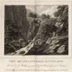
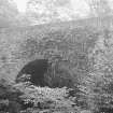
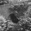
Rumbling Bridge


Road Bridge (Period Unknown)
Site Name Rumbling Bridge
Classification Road Bridge (Period Unknown)
Alternative Name(s) Falls Of The Braan; River Braan
Canmore ID 26250
Site Number NN94SE 7
NGR NN 99662 41225
Datum OSGB36 - NGR
Permalink http://canmore.org.uk/site/26250


- Council Perth And Kinross
- Parish Little Dunkeld
- Former Region Tayside
- Former District Perth And Kinross
- Former County Perthshire

