Pricing Change
New pricing for orders of material from this site will come into place shortly. Charges for supply of digital images, digitisation on demand, prints and licensing will be altered.
Upcoming Maintenance
Please be advised that this website will undergo scheduled maintenance on the following dates:
Thursday, 9 January: 11:00 AM - 3:00 PM
Thursday, 23 January: 11:00 AM - 3:00 PM
Thursday, 30 January: 11:00 AM - 3:00 PM
During these times, some functionality such as image purchasing may be temporarily unavailable. We apologise for any inconvenience this may cause.
Crofthead Farm
Standing Stone(S) (Prehistoric)
Site Name Crofthead Farm
Classification Standing Stone(S) (Prehistoric)
Alternative Name(s) The Thorn
Canmore ID 26192
Site Number NN92SW 4
NGR NN 9203 2404
Datum OSGB36 - NGR
Permalink http://canmore.org.uk/site/26192
- Council Perth And Kinross
- Parish Fowlis Wester
- Former Region Tayside
- Former District Perth And Kinross
- Former County Perthshire
NN92SW 4 9203 2404
See also NN92SW 3 and NN92SW 57.
(NN 9203 2404) Standing Stones (NR).
OS 6" map (1958)
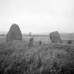
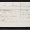
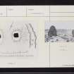
Two standing stones 5ft 3ins and 7ft high respectively, standing on two well-defined mounds.
F R Coles 1911
As described and illustrated by Coles. The 'mounds' are of no significance.
Resurveyed at 1/2500.
Visited by OS (RD) 12 December 1966.
These two standing stones are as described by Coles at the edge of an arable field. From their elevated situation on the ridge, they command a broad vista to the SE and S. A line drawn from the New Fowlis cairn (NN92SW 2) to a point midway between the two standing stones would pass through what was probably the original position of the cup-marked stone NN92SW 3
Visited by RCAHMS (RJCM, JRS), 10 November 1995.
F R Coles 1911.
Field Visit (17 August 1942)
Fowlis Wester, standing stones.
Due W of Fowlis Wester between the farms of Crofthead and Thorn stand two stones on a line bearing 65 degrees E of magnetic N with an interval of 10’8” between them. The W stone stands 6’9” x 5’4” x 2’ and the E one 5’3” x 3’9” x 2’4”. They stand on level ground now cultivated beside a ditch that carries a stream.
Visited by RCAHMS (VGC) 17 August 1942.


