
Following the launch of trove.scot in February 2025 we are now planning the retiral of some of our webservices. Canmore will be switched off on 24th June 2025. Information about the closure can be found on the HES website: Retiral of HES web services | Historic Environment Scotland
Mosshead


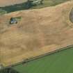
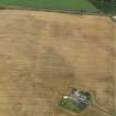
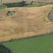
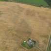
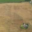
Burial (Period Unassigned)(Possible), Enclosure (Period Unassigned), Ring Ditch(S) (Period Unassigned)
Site Name Mosshead
Classification Burial (Period Unassigned)(Possible), Enclosure (Period Unassigned), Ring Ditch(S) (Period Unassigned)
Alternative Name(s) Dunning
Canmore ID 26072
Site Number NN91SE 33
NGR NN 989 149
Datum OSGB36 - NGR
Permalink http://canmore.org.uk/site/26072


- Council Perth And Kinross
- Parish Dunning
- Former Region Tayside
- Former District Perth And Kinross
- Former County Perthshire
Project (17 June 2009 - 28 July 2009)
Watching briefs were kept between 17 June–28 July during the refurbishment of parts of the Forteviot-Dunning-Aberuthven 11kV overhead and underground power line.
J Lewis 2009
Watching Brief (17 June 2009 - 28 July 2009)
NN 98963 14844 – NN 98875 14756
The excavation of a 150m long trench for an underground cable was monitored at Laigh of Rossie, 1km SE of Aberuthven, due to the proximity of a possible early medieval cemetery (NN91SE 33). Nothing of archaeological significance was uncovered.
Archive and Report: Perth and Kinross SMR and RCAHMS
Funder: Scottish and Southern Energy plc
J Lewis 2009

