
Pricing Change
New pricing for orders of material from this site will come into place shortly. Charges for supply of digital images, digitisation on demand, prints and licensing will be altered.
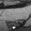
Boysack


Enclosure (Period Unknown)(Possible), Pit(S) (Period Unknown), Ring Ditch (Period Unknown)
Site Name Boysack
Classification Enclosure (Period Unknown)(Possible), Pit(S) (Period Unknown), Ring Ditch (Period Unknown)
Canmore ID 259733
Site Number NO64NW 139
NGR NO 6163 4916
Datum OSGB36 - NGR
Permalink http://canmore.org.uk/site/259733


- Council Angus
- Parish Inverkeilor
- Former Region Tayside
- Former District Angus
- Former County Angus
NO64NW 139 6163 4916
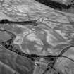
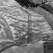
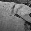
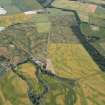
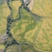
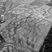
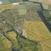
A possible enclosure, pits and a ring-ditch have been recorded as cropmarks on oblique aerial photography (RCAHMSAP 2000) on level ground about 500m WNW of Boysack. The enclosure is roughly rectilinear in plan and the ring-ditch, which is defined by a narrow ditch and may be a roundhouse, lies in the interior. There is a scatter of pits across the field. A gas pipeline runs N-S immediately to the W of the enclosure.
Information from RCAHMS (KMM) 2 June 2004

